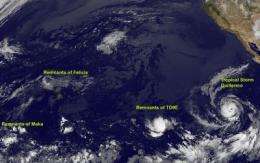
GOES-11 sees tropical cyclones fizzling and forming in the Eastern Pacific

There are a lot of ups and downs in tropical cyclone formation in the Pacific Ocean this week, and that's keeping NOAA's GOES-11 satellite busy. There are remnants of Maka and Tropical Depression 9E, a fizzled Felicia, and a new Tropical Storm named Guillermo.
The graphics folks that create images from the satellite at the GOES Project at NASA Goddard Space Flight Center in Greenbelt, Md. are posting updated images on the GOES Project website often and forecasters are watching them.
In the Central Pacific Ocean, Maka and Felicia are now a memory. Felicia dissipated before it reached Hawaii, and the remnants of Maka are 1,400 miles west-southwest of Kauai. Maka's remnant clouds and showers are still moving west, and it's unlikely that it will re-organize. That means a quiet Central Pacific Ocean for the next two days.
In the Eastern Pacific, Tropical Depression 9E (TD9E) appears to be fizzling although it may get a second chance at life, while Tropical Depression 10E powered up into Tropical Storm Guillermo.
The remnants of TD9E are weakly spinning to around 30 mph, while it continues moving west-southwest near 9 mph. The center was located about 1,750 miles west-southwest of the southern tip of Baja California, near 13.9 north and 134.1 west. The National Hurricane Center noted that shower and thunderstorm activity has increased this morning, and the environment seems to be a little more conducive to strengthening, so TD9E isn't written off yet. In fact, there's about a 30-50% chance it may strengthen back into a tropical depression.
Meanwhile, Tropical Depression 10E gained strength took the name Guillermo and it's sustained winds whipped up to near 50 mph. Guillermo is moving west-northwest near 16 mph and will continue in that direction. Guillermo is closer to mainland Mexico, but poses no threat as its heading away from land. On Aug. 13 at 5 a.m. EDT the storm was located 805 miles west-southwest of the southern tip of Baja California near 16.9 north and 120.5 west. His minimum central pressure is 999 millibars. Guillermo is moving into a favorable environment, so he's expected to continue strengthening.
Even though the peak of hurricane season in the eastern and central Pacific Oceans are a month away, it seems like we're already there.
Source: NASA/Goddard Space Flight Center


