Cyclone Bijli's rainfall -- from birth to death (w/Video)

Before satellites, meteorologists had no way to estimate or measure how much rain tropical cyclones generated where there were no buoys with rain gauges. The satellite managed by NASA and the Japanese Space Agency, JAXA provides that "rain gauge" from space in the Tropical Rainfall Measuring Mission (TRMM) satellite.
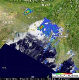
NASA's TRMM mission page has unveiled an animation of the rainfall created by Cyclone Bijli from the time it was born until the time it made landfall on Apr. 17, 2009 in Bangladesh.
TRMM data, along with information from other satellites, allows researchers to see how much rain is falling over most of the world every three hours and map areas of potential flooding. Maps that show areas of potential floods use precipitation radar data and high resolution measurements of water content of clouds made by microwave radiometers.
Those rainfall maps were made into a seven-day "movie loop" that allows users to track storms as they travel over land and oceans around the globe.
The rainfall animations are developed in the Laboratory for Atmospheres of the NASA Goddard Space Flight Center, Greenbelt, Md. by the TRMM precipitation research team.
This animation shows Cyclone Bijli's rainfall from the time it was "born" on April 13 in the Bay of Bengal as "storm 94B," intensified into tropical depression and renamed "01B" and then grew into Tropical Storm Bijli where it made landfall in southern Bangladesh on April 17.
The TRMM Multi-Satellite Precipitation Analysis estimates that Bijli dropped as much as 129 millimeters (5.07 inches) of rainfall on Bangladesh, near 22.13 latitude and 90.63 longitude. That location is approximately 37.20km (23 miles) from coastal area of Patuakhali, a district in South-western Bangladesh.
The Hindu newspaper reported that Bijli hit the Chittagong Cox's Bazar coast hardest, bringing heavy rainfall and tropical storm-force wind gusts to 90 km/hour (55 mph) on Friday evening, April 17. The storm fizzled out the next day, but not before killing five people. Reports indicated that over 300,000 people evacuated before Bijli made landfall.
Source: NASA/Goddard Space Flight Center


