NASA sees tropical storm noul strengthening, organizing

The RapidScat instrument that flies aboard the International Space Station and measures surface winds gathered data that showed newborn Tropical Storm Noul strengthening and organizing.
Tropical Storm Noul developed on Sunday, May 3 and began its life as Tropical Depression 06W, just 192 nautical miles (220.9 miles/355.6 km) east of Yap and triggered a tropical storm watch for Fais, Ulithi, Ngulu and Yap Island in Yap State of Micronesia.
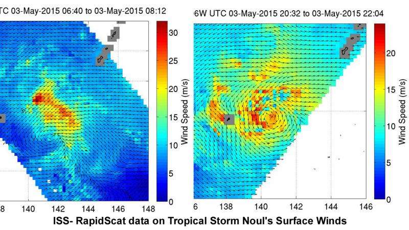
On May 3, RapidScat obtained data twice on Tropical Depression 06W. The first pass of RapidScat data was gathered between 06:40 and 08:12 UTC (2:40 and 4:12 a.m. EDT). That data showed the storm's winds north of the low-level center of circulation had rapidly intensified had sustained winds as high as 65 knots (74.8 mph/120.4 kph) in the first pass. Those sustained wind speeds were not as high in the other quadrants of the storm.
By the second RapidScat pass, data taken between 20:32 and 22:34 UTC (4:32 p.m. and 6:34 p.m. EDT) showed the strongest winds closer to 50 knots (57.5 mph/92.6 kph) were occurring on the western and northern sides of the storm. The second RapidScat pass also showed that the storm's circulation had become more organized and more circular.
By Monday, May 4, that watch was replaced with a Tropical Storm Warning for Fais, Ulithi and Yap Island in Yap State. A typhoon watch was in effect for Yap Island.
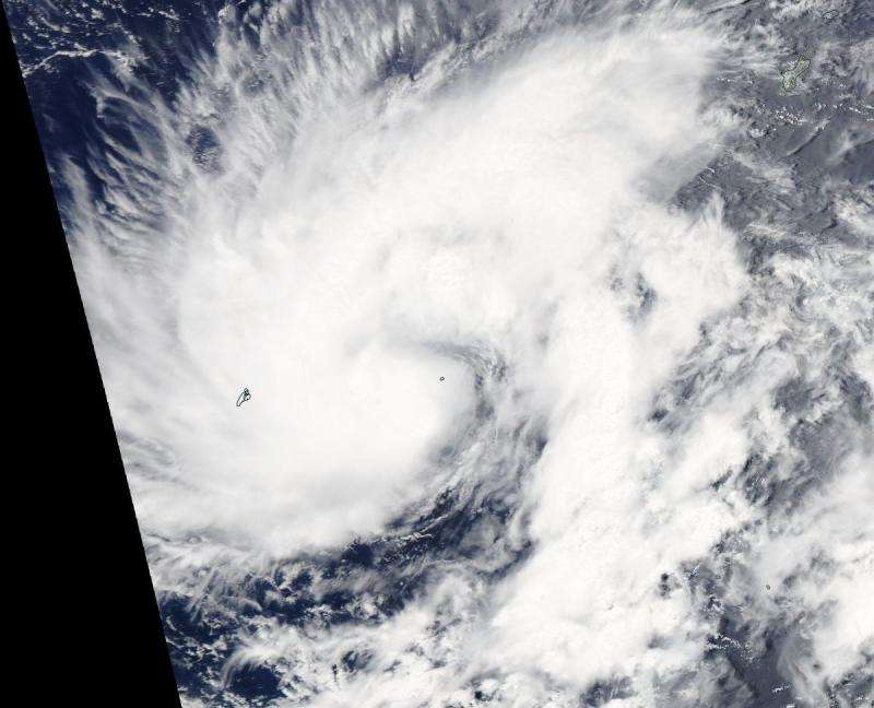
On May 4, the Moderate Resolution Imaging Spectroradiometer or MODIS instrument aboard NASAs Aqua satellite captured a visible image of Tropical Storm Noul as it moved hear Ulithi. Ulithi is an atoll located about 103 nautical miles (118.5 miles/190.8 km) east of Yap. Thunderstorms have increased in intensity over a tightly-wrapped band situated along the western edge of the low level circulation center.

By 1500 UTC (11 a.m. EDT), Tropical storm Noul's maximum sustained winds were near 45 knots (51.7 mph/83.3 kph) with higher gusts. It was centered near 9.6 north latitude and 139.7 east longitude, just 24 nautical miles (27.6 miles/44.4 km) east-southeast of Ulithi. Noul was moving very slowly at 3 knots (3.4 mph/5.5 kph) to the west-southwest and generating 15-foot (4.5 meter)-high seas.
Noul is moving in a westerly direction and the Joint Typhoon Warning Center (JTWC) forecast expects it to reach typhoon strength on May 6 near Yap. The extended JTWC forecast track takes Noul toward Luzon, the northern Philippines by May 9. For updated forecasts from the Philippine Atmospheric, Geophysical and Astronomical Services Administration, visit: pagasa.dost.gov.ph.
Provided by NASA's Goddard Space Flight Center


