NASA sees Typhoon Maysak weakening

Various NASA satellites and instruments continue to see the weakening trend in Typhoon Maysak as it moved through the Philippine Sea on April 2 and 3 toward a landfall in Luzon on April 4. Maysak is known locally in the Philippines as Typhoon Chedeng.
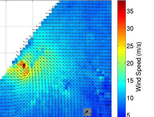
On April 2, the International Space Station's NASA RapidScat instrument analyzed Maysak's winds from 9:10 to 10:43 UTC (5:10 a.m. to 6:43 a.m. EDT) and data found strongest surface winds were northeast of the eye, near 40 m/s (89.4 mph/144 kph/77.7 knots).
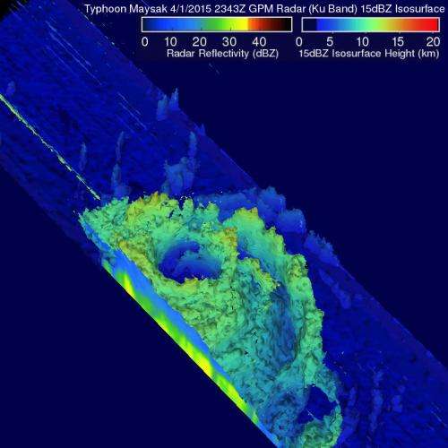
The Global Precipitation Measurement or GPM core observatory satellite passed above Typhoon Maysak on April 2, 2015 at 23:43 UTC (7:43 p.m. EDT). GPM's Microwave Imager (GMI) found heavy rain in Maysak's northwestern side but the typhoon had weakened from its peak intensity of over 130 knots (150 mph/241 kph) to about 115 knots (132 mph/213 kph) at the time of GPM passed overhead.
GPM's Radar (Ku Band) was used to create a 3-D view to show the vertical structure of the thunderstorms that make up Maysak. The three dimensional view was created looking toward the southwestern side of Maysak's eye, and showed that the eye wall was eroding on that side. Some of the highest thunderstorms around the eye were near 9.3 miles (15 km) high. Vertical wind shear has contributed to Typhoon Maysak's continued weakening.
On April 3, Public Storm Warning Signal #1 were in effect in the Philippines for the Luzon provinces of Isabela, Aurora, Quirino, Quezon including Polillo Island, Catanduanes, Camarines Norte and Camarines Sur. For updated warnings and watches, visit: http://pagasa.dost.gov.ph/index.php/tropical-cyclones/weather-bulletin.
The Moderate Resolution Imaging Spectroradiometer or MODIS instrument that flies aboard NASA's Aqua satellite captured a visible image of Typhoon Maysak moving west-northwest through the Philippine Sea at 04:25 UTC (12:25 a.m. EDT). Maysak's eye was still visible on the MODIS image, although it appeared it was topped by high clouds. Bands of thunderstorms circled the eye and wrapped into the center from the north and east of the center.

By 1500 UTC (11 a.m. EDT) Typhoon Maysak's maximum sustained winds dropped to 85 knots (97.8 mph/157.4 kph). That makes Maysak a Category 2 typhoon on the Saffir-Simpson Wind Scale. Hurricane-force winds extended to about 30 nautical miles (34.5 miles/55.5 km) outward from the center. Maysak was centered near 14.4 north latitude and 128.5 east longitude, about 471 nautical miles (542 miles/872.3 km) east of Manila, Philippines. Maysak was moving to the west at 9 knots (10.3 mph/16.6 kph).
The Joint Typhoon Warning Center (JTWC) predicts that Maysak will be a tropical storm when it makes landfall on April 4 in the northern Philippines. Passage across land will weaken Maysak, and the storm is expected to dissipate over the South China Sea.
Provided by NASA's Goddard Space Flight Center


