NASA sees Nathan weakening near Darwin, Australia

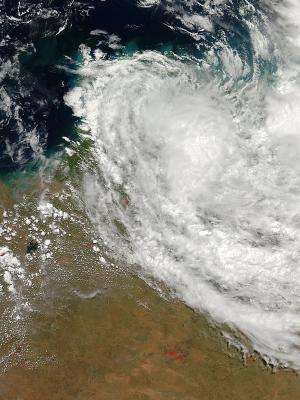
Tropical Cyclone Nathan has been weakening as it continued to move over land in Australia's Northern Territory on March 24. NASA's Aqua satellite captured a visible picture of the storm over land. Just one day before the Tropical Rainfall Measuring Mission satellite saw some heavy rainfall in Nathan.
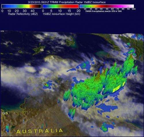
The Tropical Rainfall Measuring Mission (TRMM) satellite captured rainfall rate and cloud height data when it passed above Nathan on March 23, 2015 at 0631 UTC (2:31 a.m. EDT) before Nathan moved inland. Nathan had intensified and had hurricane force winds of about 65 knots (75 mph). TRMM's Precipitation Radar (PR) data showed that Nathan had a few areas of very heavy precipitation along Australia's Arafura Sea coast. TRMM's Precipitation Radar (PR) found that the tops of a few thunderstorms in intense rain bands rotating around Nathan's northwestern side reached heights above 15.5 km (9.6 miles).
On March 24 at 05:20 UTC (1:20 a.m. EDT), the Moderate Resolution Imaging Spectroradiometer or MODIS instrument aboard NASA's Aqua satellite captured a visible image of Tropical Cyclone Nathan over the Top End of the Northern Territory, Australia. The storm appeared elongated with a concentration of strongest storms near the center, and a band of thunderstorms around the northwestern periphery.
The Joint Typhoon Warning Center (JTWC) issued the final warning on Tropical Cyclone Nathan today, March 24 at 0900 UTC (5 a.m. EDT). The Australian Bureau of Meteorology (ABM) noted Ex-Tropical Cyclone Nathan was moving across the northwest Arnhem district. The remnant tropical low is expected to track toward the west toward the Southern Indian Ocean.
ABM noted that Nathan's remnants will generate thunderstorms with gusty winds and heavy rainfall which may lead to flash flooding in the southern Arnhem forecast district and extending to parts of the Daly forecast district on Wednesday, March 25. ABM stated that locations that may be affected include Douglas River, Nauiyu, Peppimenarti, Barunga, Beswick, Bulman, Central Arnhem Plateau, Ngukurr, Numbulwar and Litchfield National Park. For updated information, visit: http://www.bom.gov.au/nt/warnings/.

Nathan's maximum sustained winds dropped to 30 knots (34.5 mph/55.5 kph) as it continued to move across land in the Top End of Australia's Northern Territory. Nathan was centered near 12.5 south latitude and 132.4 east longitude, just 88 nautical miles (101.3 miles/163 km) east of Darwin, Australia. It was moving to the west-southwest at 7 knots (8 mph/12.9 kph).
Today, March 24, Nathan continues weakening inland and adverse conditions will prevent re-strengthening over the next few days as the remnant low moves. There is some potential for regeneration by the end of the week once it moves into the Southern Indian Ocean.
Provided by NASA's Goddard Space Flight Center


