NASA sees new tropical storm threatening Mauritius and Reunion Islands

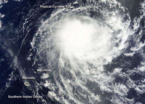
NASA's Terra satellite passed over Tropical Cyclone 02S after it formed in the Southern Indian Ocean on Nov. 28. An image from Terra showed that the new tropical storm is close to Mauritius and Reunion Islands.
The Moderate Resolution Imaging Spectroradiometer or MODIS instrument aboard NASA's Terra satellite captured a visible image of newborn Tropical Cyclone 02S northeast of the islands of Mauritius and Reunion. The MODIS image showed that thunderstorms were mostly west of the low-level center of circulation and bands of thunderstorms were wrapping into the center. A microwave image also showed that wind shear pushed the bulk of the deep convection and strong thunderstorms west of the defined low-level center.
On Nov. 28 at 1500 UTC (10 a.m. EST), Tropical Cyclone 02S had maximum sustained winds near 35 knots (40 mph/64 kph). It was centered near 16.6 South longitude and 61.2 East latitude, about 430 nautical miles (494.8 miles/796.4 kilometers) northeast of St. Denis. Tropical Cyclone 02S was moving to the southwest at 14 knots (16.1 mph/25.9 kph).
A sub-tropical ridge or elongated area of high pressure located to the east-southeast of the tropical storm will continue steering it to the southwest. Thereafter a mid-latitude trough (elongated area) of low pressure will steer it southward.
Over the next couple of days, Mauritius and Rodrigues Islands are expected to receive gusty winds, showers and rough seas as Tropical Cyclone 02S moves closer. Mauritius Meteorological Service updates can be found at: http://metservice.intnet.mu/warning-bulletin-special-weather.php
In three days, vertical wind shear is expected to increase and the tropical cyclone is forecast to move into cooler waters. Those two factors will weaken the storm. According to the Mauritius Meteorological Services, the tropical cyclone will pass close to Mauritius by Sunday when it will likely be a depression.
Provided by NASA's Goddard Space Flight Center


