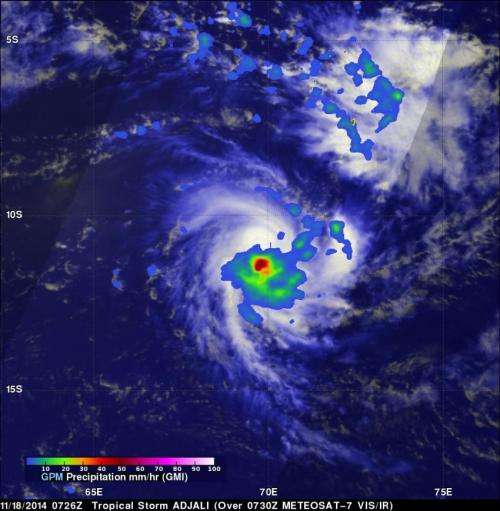
GPM measured Tropical Storm Adjali's rainfall before dissipation

Moderate rainfall was occurring around the center of Tropical Storm Adjali before it dissipated, according to data from NASA and the Japan Aerospace Exploration Agency's Global Precipitation Measurement or GPM satellites.
Adjali became the first named storm of the Southwest Indian Ocean 2014/2015 cyclone season when it formed on November 16, 2014. Adjali became a strong tropical storm the next day and just two days later started to dissipate.
The GPM observatory captured data on Adjali's rainfall rates on Nov. 18. GPM's Microwave Imager (GMI) instrument is similar to the Tropical Rainfall Measuring Mission's (TRMM's) Microwave Imager (TMI) which also provide rainfall rates of storms, but TRMM is limited to the tropics while GPM provides near real time global coverage of precipitation.
When GPM flew over Adjali on November 18, 2014 at 0726 UTC (2:26 a.m. EST), GPM's Microwave Imager (GMI) instrument collected data on the rate in which rainfall was occurring. GMI data showed that rain was falling at a rate of over 69 mm/about 2.7 inches per hour near the center of the tropical storm.
To create a total picture of the storm, the GPM rainfall data was combined with a visible/infrared image of Adjali's clouds as seen from Europe's METEOSAT-7 on November 18, 2014 at 0730 UTC. That image was created at NASA's Goddard Space Flight Center in Greenbelt, Maryland.
Late on Nov. 19 the atmospheric conditions around Tropical Cyclone Adjali became hostile as wind shear increased and tore the storm apart. At 2100 UTC (4 p.m. EST) the Joint Typhoon Warning Center (JTWC) issued their final bulletin on the storm. At that time, Tropical Cyclone Adjali was centered near 13.3 south latitude and 70.0 east longitude, about 400 nautical miles south-southwest of the island of Diego Garcia. It was moving to the west-northwest at 4 knots (4.6 mph/7.4 kph) and had maximum sustained winds near 35 knots (40 mph/64 kph). The JTWC noted at that time that "Adjali is currently dissipating under hostile conditions."
By November 20, Adjali had dissipated in the Southern Indian Ocean putting an end to the first tropical cyclone of the Southern Indian Ocean season.
Global Precipitation Measurement (GPM) is an international satellite mission that will set a new standard for precipitation measurements from space, providing the next-generation observations of rain and snow worldwide every three hours. The GPM mission data will advance our understanding of the water and energy cycles and extend the use of precipitation data to directly benefit society.
More information: For more information about GPM, visit: http://www.nasa.gov/gpm
Provided by NASA's Goddard Space Flight Center


