TRMM and GPM satellites analyze Hurricane Vance before landfall

Hurricane Vance was a hurricane on Nov. 4 when the Tropical Rainfall Measuring Mission or TRMM satellite and the Global Precipitation Measurement (GPM) mission satellite passed overhead and measured its rainfall from space. TRMM and GPM revealed areas of heavy rain within the storm before it weakened to a depression and made landfall on Nov. 5.
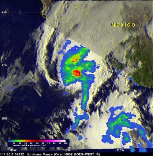
The TRMM satellite flew over hurricane Vance on Nov. 4 at 0953 UTC (4:53 a.m. EST). Rainfall derived from TRMM's Microwave Imager (TMI) data collected were overlaid on a 1000 UTC (5 a.m. EST) image from NOAA's GOES-West satellite showing cloud cover and extent. The image analysis showed that Vance had a large area of heavy rainfall near the center of the hurricane. Some intense storms in that area were dropping rain at a rate of over 50mm (2 inches) per hour.
Vance's power peaked late on November 3, 2014 with winds of about 95 knots (about 109 mph). Vertical wind shear had started to weaken the hurricane, but Vance was still a powerful category two hurricane on the Saffir-Simpson scale with sustained wind speeds of about 90 knots (about 104 mph).
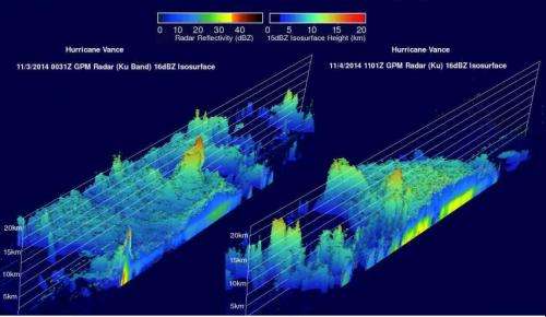
GPM, the successor to the TRMM satellite had two excellent views of Hurricane Vance on both November 3 at 0031 UTC and on Nov. 4 at 1101 UTC. GPM's Radar (Ku band), that is similar to that used on the TRMM's satellite, was used to show vertical structure of precipitation at both times. In the first view hurricane Vance was at close to peak power with a well-defined eye. On Nov. 4, the weakening hurricane had a closing eye with much lower thunderstorm tops.

Tropical Depression Vance Makes Landfall
Increasing vertical wind shear weakened Vance from a hurricane to a depression by Nov. 5. In fact, wind shear had increased so much it was blowing at over 50 knots early in the day.
Vance made landfall in western Mexico around 10 a.m. EST today, Nov. 5. At that time, an automated weather station located in the northern part of the state of Nayarit, Mexico, reported a wind gust of 52 mph (84 kph).
On Wednesday, Nov. 5 at 10 a.m. EST (7 a.m. PST/1500 UTC) the center of Tropical Depression Vance was located near latitude 22.7 north and longitude 105.7 west about 55 miles (90 km) southeast of Mazatlan, Mexico. The depression was moving toward the northeast near 13 mph (20 kph) and is expected to continue in that direction taking Vance farther inland. The estimated minimum central pressure is 1005 millibars. Maximum sustained winds had decreased to near 30 mph (45 kph) and Vance is expected to dissipate later today or tonight.
Vance may be dissipating, but the moisture associated with the depression will continue to bring heavy rainfall southeast of its center and across portions of central and northern Mexico and the south-central United States. The ocean swells creating dangerous conditions and rip currents affecting parts of the southwestern Mexico and Baja California Sur coastlines are expected to diminish late on Nov. 5.
Forecaster Cangialosi at NOAA's National Hurricane Center (NHC) noted that by 10 a.m. EST on Nov. Vance's low-level center was becoming elongated, so the cyclone barely met the qualifications for a tropical cyclone.
The moisture that TRMM and GPM saw when Vance was a hurricane will continue to generate heavy rainfall. Even though the tropical cyclone is forecast to dissipate soon, the NHC discussion stated that moisture from the remnants of Vance and the area to its southeast should continue to spread northeastward across Mexico and into the south-central United States. This is producing heavy rains over portions of these areas, which should continue for another day or two.
Provided by NASA's Goddard Space Flight Center


