Major Hurricane Gonzalo gives an 'eye-opening' performance

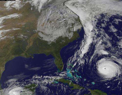
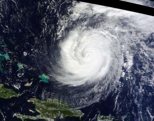
NASA and NOAA satellites have been providing continuous coverage of Hurricane Gonzalo as it moves toward Bermuda. NASA's Terra satellite saw thunderstorms wrapped tightly around the center with large bands of thunderstorms wrapping into it. NOAA's GOES-East satellite provided and "eye-opening" view of Gonzalo, still a Category 4 hurricane on Oct. 16.
A hurricane warning is in effect for Bermuda and that means that hurricane conditions are expected within the warning area, meaning the entire island.
On Oct. 15 at 15:30 UTC (11:30 a.m. EDT) the Moderate Resolution Imaging Spectroradiometer or MODIS instrument aboard NASA's Terra satellite captured a visible picture of Hurricane Gonzalo in the Atlantic Ocean. The image revealed a cloud-covered center with strong thunderstorms surrounding the eye as bands of strong thunderstorms in the southern, eastern and northern quadrants spiraled into the center.
NOAA's GOES-East satellite captured an image of Hurricane Gonzalo off the U.S. East Coast on Oct. 16 at 13:07 UTC (9:07 a.m. EDT) and showed that Gonzalo's eye had become cloud-free. The image also showed a line of clouds associated with a cold front stretching over 1,600 miles that just moved off the U.S. East coast and headed toward Gonzalo.
On Thursday, Oct. 16 at 8 a.m. EDT, Hurricane Gonzalo was still a major hurricane with maximum sustained winds near 140 mph (220 kph). Hurricane force winds extend outward up to 45 miles (75 km) from the center and tropical storm force winds extend outward up to 150 miles (240 km).
Fluctuations in intensity are common in major hurricanes. The National Hurricane Center (NHC) cautioned that "Slow weakening is forecast but Gonzalo is expected to be a dangerous hurricane when it moves near Bermuda."

Gonzalo's eye was located by a NOAA Hurricane Hunter near latitude 25.5 north and longitude 68.7 west. That puts the eye of Gonzalo about 525 miles (845 km) south-southwest of Bermuda. The minimum central pressure measured by the NOAA Hurricane Hunter aircraft is 940 millibars.
Gonzalo is moving toward the north near 9 mph (15 kph) and this general motion is expected to continue today. The NHC forecast calls for a turn toward the north-northeast and an increase in forward speed tonight (Oct. 16) and Friday (Oct. 17). On the forecast track, the center of Gonzalo is expected to pass near Bermuda on Friday.
The NHC expects hurricane-force winds, and rainfall totals of 3 to 6 inches in Bermuda. A storm surge with coastal flooding can be expected in Bermuda, with large and destructive waves along the coast. In addition, life-threatening surf and riptide conditions are likely in the Virgin Islands, Puerto Rico, Dominican Republic, Bahamas. Those dangerous conditions are expected along the U.S. East Coast and Bermuda later today, Oct. 16.
The NHC forecast calls for Gonzalo to remain a major hurricane on its approach to landfall in Bermuda.
More information
For updated information and forecasts, visit www.nhc.noaa.gov
Provided by NASA's Goddard Space Flight Center


