NASA sees newborn Tropical Storm Gonzalo form and threaten Caribbean islands

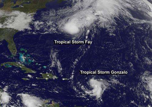
Tropical Storm Gonzalo formed quickly on Oct. 12 just east of the Leeward Islands, triggering tropical storm warnings for many islands. NOAA's GOES-East satellite captured an image of the newborn storm on Sunday, Oct. 12, and Tropical Storm Fay northeast of Bermuda.
The GOES East satellite is a geostationary satellite managed by NOAA. At NASA's Goddard Space Flight Center in Greenbelt, Maryland the NASA/NOAA GOES Project creates images and animations and today's visible image, taken at 2:45 p.m. EDT showed a smaller Gonzalvo east of the Leeward Islands while Fay was northeast of Bermuda.
A Tropical Storm Warning is in effect for Guadeloupe, Desirade, Les Saintes, Marie Galante, St.Martin, St. Barthelemy, St.Maartin, Saba, St. Eustatius, Barbuda, Antigua, Anguilla, St. Kitts, Nevis, Montserrat A Tropical Storm Watch in effect for Puerto Rico, Vieques, Culebra, U.S. Virgin Islands and the British Virgin Islands. A tropical storm warning means that tropical storm conditions are expected somewhere within the warning area...in this case within the next 24 to 36 hours.
On Sunday, Oct. 12 at 1:30 p.m. EDT, Tropical Storm Gonzalo had maximum sustained winds near 40 mph (65 kph) and is expected to strengthen over the next two days. Gonzalo was about 200 miles (320 km) east of Guadeloupe and 230 miles (370 km) east-southeast of Antigua, near latitude 16.4 north and longitude 58.4 west. Gonzalo was moving to the west at 10 mph (17 kph) and is expected to continue in that direction for the next two days before turning to the west-northwest.
The National Hurricane Center expects Gonzalo to move through the Leeward Islands early Monday morning, Oct. 12.
Tropical storm conditions are possible within the watch area by Monday night and Tuesday morning. Tropical Storm Gonzalo is expected to produce total rainfall accumulations of 4 to 8 inches across the Leeward Islands...British and U.S. Virgin Islands and Eastern Puerto Rico with isolated maximum totals of 12 inches possible. Swells generated by Gonzalo will affect the Leeward Islands tonight and Monday morning from Dominica northward and affect the U.S. and British Virgin islands by Monday afternoon. These swells are likely to cause life-threatening surf and rip current conditions.
Provided by NASA's Goddard Space Flight Center


