NASA eyes Super typhoon Vongfong

Typhoon Vongfong strengthened into a Super typhoon on Tuesday, October 7 as NASA's Aqua satellite passed overhead.
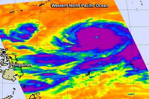
On Oct. 7 at 0429 UTC (12:29 a.m. EDT) the Atmospheric Infrared Sounder called AIRS that flies aboard NASA's Aqua satellite captured cloud top temperature data on Super typhoon Vongfong. AIRS data very strong thunderstorms circling Vongfong's clear 27 nautical-mile wide eye. Those cloud top temperatures were colder than -62F/-53C indicating that they were high in the troposphere and capable of generating heavy rainfall. The bands of thunderstorms circling Vongfong appeared symmetric on satellite imagery.
At 11 a.m. EDT on Oct. 7, Vongfong's maximum sustained winds were near 135 knots (155.4 mph/250 kph) making it a strong Category 4 Typhoon on the Saffir-Simpson hurricane scale. Vongfong's center was located near latitude 17.5 north and longitude 133.6 east. That's about 649 nautical miles (747 miles/1,202 km) southeast of Kadena Air Base, Okinawa, Japan. Vongfong is moving toward the west at 11 knots (12.6 mph/ 20.3 kph)
Vongfong is creating massive ocean swells with seas to 47 feet (14.3 meters), according to the Joint Typhoon Warning Center (JTWC).
JTWC forecasters expect Vongfong to continue tracking to the west until it runs into a trough or elongated area of low pressure sometime on Oct. 9 that will turn it to the north. By Oct. 12, the JWTC expects the center of Vongfong to be near the Japanese island of Amami Oshima. Kadena Air Base and Amami Oshima should prepare for typhoon conditions.
Provided by NASA's Goddard Space Flight Center


