Tropical Storm Simon says, 'US Southwest is an 'arm's reach'

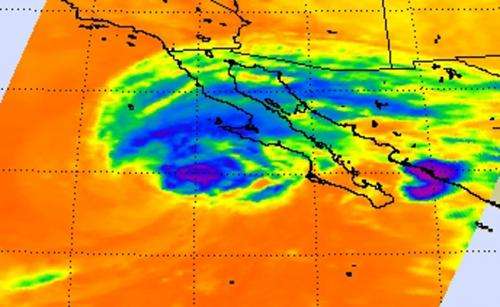
Infrared satellite imagery from NASA's Aqua satellite shows what looks like an arm from Tropical Storm Simon's northern quadrant, reaching over Baja California to mainland Mexico. Forecasters at the National Hurricane Center noted that Simon is just an "arm's reach" to the southern U.S. and expect rainfall and rough surf to affect that area of the country.
On Oct. 6 at 0347 UTC (Oct. 5 at 11:47 p.m. EDT) the Atmospheric Infrared Sounder called AIRS that flies aboard NASA's Aqua satellite captured cloud top temperature data on Simon. On band of thunderstorms wrapping into Simon's center from the north extended east over Baja California to mainland Mexico, resembling an arm.
AIRS data showed some strong thunderstorms remained around the center of Simon. Those cloud top temperatures were as cold as -62F/-53C indicating that they were high in the troposphere and capable of generating heavy rainfall.
Simon Bringing Heavy Rainfall and Rough Surf to Western Mexico
The heavy rainfall Simon is packing is threat to Baja California and mainland Mexico, according to the National Hurricane Center (NHC). Simon is expected to produce storm total rainfall amounts of 3 to 6 inches with isolated amounts around 9 inches over the next several days across central and northern portions of the Baja California peninsula and the state of Sonora in northwestern Mexico.
Simon also continues to generate rough surf along portions of the Baja California peninsula. The NHC expects the swells to begin subsiding on Oct. 7.
Simon's Remnants Expected to Affect U.S. Southwest
NHC noted that rainfall is expected to spread into portions of the U.S. desert Southwest. This rainfall could cause flash flooding and mud slides. In addition, the rough surf battering the coast of Mexico's Baja California will be felt along parts of southern California's coast today and tomorrow, Oct. 6 and 7. These swells are likely to cause life-threatening surf and rip current conditions. Swells should begin to subside on Wednesday, Oct. 7.
At 5 a.m. EDT on Oct. 6, Simon's maximum sustained winds were near 60 mph (95 kph) and weakening is expected during the next couple of days Simon's center was located near latitude 24.4 north and longitude 117.6 west. That's about 280 miles (455 km) southwest of Punta Eugenia, Mexico. Simon is moving toward the north near 7 mph (11 kph) and is expected to turn to the north-northeast is expected by Oct. 7.
Provided by NASA's Goddard Space Flight Center


