NASA sees Hurricane Cristobal racing through North Atlantic

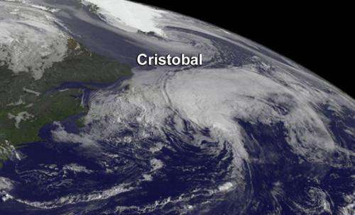
Satellite imagery shows Hurricane Cristobal racing through the North Atlantic on Friday, August 29 while losing its tropical characteristics. An image from NOAA's GOES-East satellite showed Cristobal headed south of Greenland. The previous day, NASA's TRMM satellite saw heavy rainfall occurring in the hurricane.
In a visible image from NOAA's GOES-East satellite on August 29 at 7:45 a.m. EDT, Hurricane Cristobal was moving through the North Atlantic about 500 miles southwest of Greenland. The image was created by the NASA/NOAA GOES Project at NASA's Goddard Space Flight Center in Greenbelt, Maryland.
At 5 a.m. EDT (0900 UTC) on August 29, Cristobal's maximum sustained winds were near 80 mph (130 kph). The National Hurricane Center forecast noted that Cristobal is forecast to lose its tropical characteristics later today, but it should remain a powerful extra0tropical cyclone over the North Atlantic through Sunday, August 31.
The center of Hurricane Cristobal was located near latitude 42.1 north and longitude 51.7 west. Cristobal was moving toward the northeast near 49 mph (80 kph) and is expected to continue in that direction while slowing down. The estimated minimum central pressure is 973 millibars.
The TRMM Satellite Sees Heavy Rainfall in Cristobal
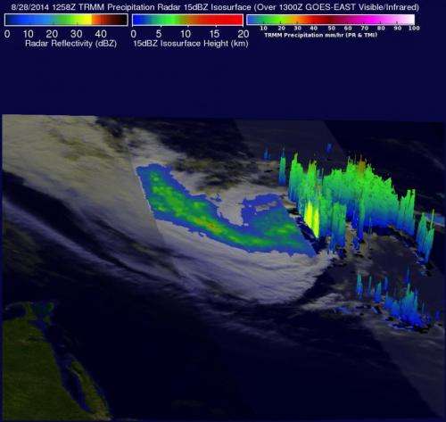
On the previous day, NASA and the Japan Aerospace Exploration Agency's Tropical Rainfall Measuring Mission (TRMM) satellite had a very good view of Cristobal on August 28 at 12:58 UTC (8:58 a.m. EDT) as the hurricane passed well to the northwest of Bermuda.

At NASA Goddard, rainfall data derived from TRMM's Microwave Imager (TMI) and Precipitation Radar (PR) data was overlaid on a visible/infrared image from NOAA's GOES-East satellite taken August 28 at 1300 UTC (9 a.m. EDT). TRMM PR found some intense thunderstorms producing rain at a rate of almost 78 mm (about 3.1 inches) per hour in a band of precipitation feeding into Cristobal's southeastern side.
The TRMM satellite was close to reaching its northern most coverage when the satellite flew over on August 28, 2014. TRMM covers the tropics, and Cristobal was moving out of range when TRMM captured data on it. The GPM satellite launched by NASA and JAXA on Feb. 27, 2014 will continue viewing hurricane Cristobal as the tropical cyclone moves farther north over the open waters of Atlantic Ocean.
Headed to the United Kingdom
The U.K. Meteorological Service (UKMS) forecast for Cristobal calls for the storm to move northeast across the Atlantic toward Iceland, staying well away from the U.K. The UKMS noted that Cristobal could bring stronger winds across northwestern parts of Scotland and rain across the United Kingdom on Sunday, August 31 and Monday, September 1.
Provided by NASA's Goddard Space Flight Center


