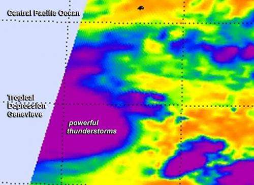
NASA sees bursts of thunderstorms in Tropical Depression Genevieve's center

The AIRS instrument aboard NASA's Aqua satellite provided a look at what's happening under Tropical Depression Genevieve's clouds using infrared light, and it appears that thunderstorms are bubbling up again.
A false-colored infrared image created at NASA's Jet Propulsion Laboratory in Pasadena California used data from the Atmospheric Infrared Sounder (AIRS) instrument that flies aboard NASA's Aqua satellite. The AIRS data showed powerful thunderstorms re-developed around Genevieve's center on August 5 at 8:35 a.m. EDT. That's an indication that there's some punch left in the storm, and that punch could help it strengthen, according to the Central Pacific Hurricane Center (CPHC).
In the August 5 discussion about Genevieve, the CPHC noted "Genevieve has continued to present a bursting pattern during the overnight hours...with the low level circulation center estimated to be under the southeastern portion of an area of very cold cloud tops."
At 11 a.m. EDT (1500 UTC) today, Tuesday, August 5, Genevieve's maximum sustained winds were near 35 mph (55 kph). The NOAA Central Pacific Hurricane Center notes that gradual strengthening is forecast today through Wednesday, and Genevieve may become a tropical storm later today.
The center of tropical depression Genevieve was located near latitude 11.1 north, longitude 171.1 west. That's about 1,120 miles (1,805 km) southwest of Honolulu, Hawaii and 400 miles (645 km) south-southwest of Johnston Island. The depression is moving toward the west-northwest near 14 mph (22 kph) and this motion is expected to continue today through Wednesday. The estimated minimum central pressure is 1005 millibars.
NOAA's CPHC calls for slow intensification over the next couple of days as the storm continues to track in a westerly direction. Genevieve is expected to cross the International Date Line in a couple of days and when it does the forecast management of the storm would covered by the Joint Typhoon Warning Center.
Provided by NASA's Goddard Space Flight Center


