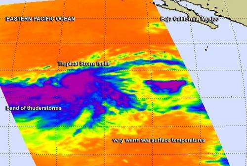
NASA eyes powerful bands of thunderstorms in newborn Tropical Storm Iselle

Tropical Storm Iselle was born in the Eastern Pacific Ocean soon after NASA's Aqua satellite gathered infrared imagery on the storm that showed powerful thunderstorms wrapping into developing storm's center. Iselle is not close enough to land to cause any watches or warnings.
The Atmospheric Infrared Sounder or AIRS instrument aboard NASA's Aqua satellite passed over System 95E on July 31 at 5:23 p.m. EDT from gathered infrared data before it became Tropical Storm Iselle. The data was made into a false-colored image at NASA's Jet Propulsion Laboratory in Pasadena, California. The AIRS data showed a large band of powerful thunderstorms west of Iselle's center wrapping into the storm. The thunderstorms had cloud top temperatures as cold as -63F/-52C indicating the cloud tops were near the top of the troposphere.
National Hurricane Center forecaster Blake noted in an August 1 discussion "A recent AMSU microwave pass also suggests that the inner core has become better defined, with perhaps a partial eyewall in the eastern semicircle." Advanced microwave sounding unit (AMSU) is a multi-channel microwave radiometer installed on meteorological satellites, including NASA's Aqua satellite that carries the AIRS instrument.
Tropical storm Iselle was born on July 31 at 2100 UTC (5 p.m. EDT). On August 1, Iselle's maximum sustained winds were already up to 60 mph (95 kph). At 5 a.m. EDT (2 a.m. PDT/0900 UTC).the center of Tropical Storm Iselle was located near latitude 13.5 north and longitude 124.6 west. Iselle is centered about 1,160 miles (1,870 km) west-southwest of the southern tip of Baja California, Mexico.
Iselle was moving toward the west-northwest near 10 mph (17 kph) and is expected to continue moving in that direction over the next couple of days.
Satellite data indicate that tropical storm force winds extend outward up to 105 miles (165 km) from the center, making the storm about 210 miles in diameter.
NHC noted that environmental conditions appear conducive for further strengthening over the next couple of days. Those conditions include light-to-moderate northeasterly shear and warm water.
The National Hurricane Center (NHC) expects Iselle to reach hurricane status by August 2.
Provided by NASA's Goddard Space Flight Center


