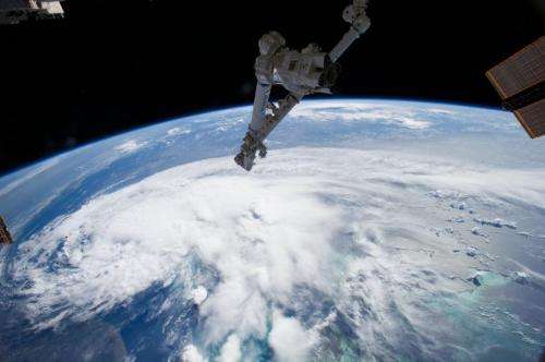
International Space Station captures image of Arthur

Looking out the window of the International Space Station, astronauts spotted a sprawling mass of clouds. The clouds were just beginning to take shape as the first tropical storm of the 2014 season built over the Atlantic.
Tropical Storm Arthur formed off southern Florida on July 1, 2014. By morning of July 2, when an astronaut took this photo with a wide-angle lens, the storm was moving north along the Florida coast. Surrounded by bright green waters, the Bahamas Islands are south of the storm in the lower right corner of the photo. T
he U.S. coastline stretches along the left side of the photo.
Arthur is forecast to become a hurricane over the next two days. It may graze or strike the Outer Banks of North Carolina as it moves north.
The National Hurricane Center has issued a hurricane watch or tropical storm warning for much of coastal North Carolina and a tropical storm watch for part of South Carolina. Please visit the National Hurricane Center for the latest warnings.
Provided by NASA


