NASA sees rainfall in newborn Tropical Depression 8W

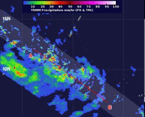
Powerful thunderstorms in some areas of newborn Tropical Depression 08W in the Northwestern Pacific Ocean were dropping heavy rainfall on July 3 as NASA's Tropical Rainfall Measuring Mission (TRMM) satellite passed overhead.
The eighth depression of the Northwestern Pacific Ocean season formed on July 3 at 0900 UTC (5 a.m. EDT). It was located near 10.0 north latitude and 144.3 east longitude about 240 nautical miles south of Andersen Air Force Base, Guam. Tropical Depression 08W or TD08W had maximum sustained winds near 30 knots (34.5 mph/55.5 kph) and it was moving to the west-northwestward at 14 knots (16.1 mph/25.9 kph).
NASA's TRMM satellite passed over TD08W on July 3 at 0851 UTC (4:51 a.m. EDT) and captured rainfall data on the storm. Some thunderstorms were as high as 9.3 miles (15 km) indicating they were "hot towers." NASA research has shown that whenever hot towers are present a storm will usually strengthen within 6 hours. Those areas also indicated heavy rainfall, where rain rates were about 2 inches (50 mm) per hour. TRMM showed that strong bands of thunderstorms were wrapping into the center of the low-level center. Additional satellite data showed that TD08W's center appeared somewhat elongated.
The Joint Typhoon Warning Center of JTWC expects TD08W to strengthen into a typhoon on July 6, after it passes to the west of Guam. JTWC forecasters then expect the typhoon to move near the Japanese islands of Kadena, Oshima and Amami by July 7 or 8.
Provided by NASA's Goddard Space Flight Center


