Cristina now a hurricane, NASA's TRMM satellite sees heavy rainfall within

Before Tropical Storm Cristina intensified into a hurricane, NASA's TRMM satellite passed overhead and gathered data that showed areas of heavy rainfall were occurring within.
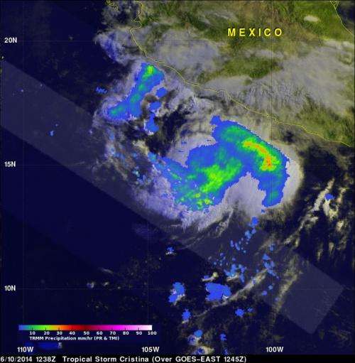
The National Hurricane Center (NHC) upgraded the third tropical depression of the Eastern Pacific Ocean to tropical storm status and named it Cristina on June 10 at 0300 UTC (8 p.m. PDT). Earlier that morning at 1238 UTC (5:38 a.m. PDT), the Tropical Rainfall Measuring Mission (TRMM) satellite flew over the depression and gathered rainfall data that hinted that the storm was intensifying. At NASA's Goddard Space Flight Center in Greenbelt, Maryland, rainfall from TRMM's Microwave Imager (TMI) and Precipitation Radar (PR) were overlaid on an enhanced visible/infrared 1245 UTC (8:45 a.m. EDT) image from the GOES-East satellite to provide a view of clouds and rainfall within the storm. The TRMM TMI data showed large areas of moderate to heavy rainfall occurring west of Mexico's coast. TRMM data also showed a closed low- to mid-level ring of thunderstorms surrounding Cristina's center.
On June 11, NHC Forecaster Kimberlain noted that Cristina continues to intensify. The cyclone consists of a small central dense overcast in geostationary satellite imagery. Infrared imagery, such as that from the Atmospheric Infrared Sounder instrument aboard NASA's Aqua satellite, showed that cloud top temperatures in powerful thunderstorms in the northern semicircle of the storm are as cold as -80C (-112F). Cloud top temperatures that cold indicate strong storms with the potential to drop heavy rainfall, which complemented the data seen by the TRMM satellite on June 10. Kimberlain also noted that there were faint hints of eye or warm spot during the early morning hours of June 11.

At 5 a.m. EDT (2 a.m. PDT), Hurricane Cristina had maximum sustained winds near 75 mph (120 kph). Cristina was centered near 15.2 north latitude and 104.1 west longitude, about 265 miles (425 km) south of Manzanillo, Mexico. Cristina is moving west at 6 mph (9 kph) and is expected to turn to the west-northwest over the next couple of days, according to NHC. Minimum central pressure was 990 millibars
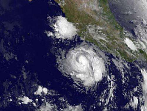
NOAA's GOES-West satellite captured an infrared view of Hurricane Cristina on June 11 at 1200 UTC/8 a.m. EDT off the west coast of Mexico. The image did not yet show an eye, but the NHC expects Cristina to continue strengthening so future satellite imagery may catch that eye "opening."
Although Cristina is not over land, it is close enough to cause dangerous ocean swells that are affecting portions of the south-central and southwestern coast of Mexico. NHC noted that these swells will likely continue into Wednesday, June 11, and could cause life-threatening surf and rip current conditions.
The NHC noted that the environment in which Cristina is embedded remains ideal for further intensification.
Provided by NASA's Goddard Space Flight Center


