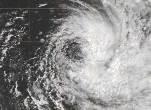
NASA satellite imagery shows Cyclone Imelda one-sided

An upper-level low pressure system is sapping the cloud and thunderstorm development on the western side of Cyclone Victoria in the Southern Indian Ocean. New NASA satellite imagery showed that the bulk of rainfall was located east of the storm's center.
At 0900 UTC (5 a.m. EDT) on April 12, Tropical Cyclone Imelda was tropical storm strength with maximum sustained winds near 45 knots (51.7 mph/83.3 kph). Imelda was centered near 14.1 south latitude and 58.9 east longitude, about 465 miles north-northeast of La Reunion Island. Imelda is moving to the south-southeast at 6 knots (7 mph/11.1 kph) and away from La Reunion.
NASA's Aqua satellite passed over Tropical Cyclone Imelda on April 12 at 1010 UTC (6:10 a.m. EDT). The Moderate Resolution Imaging Spectroradiometer (MODIS) instrument aboard Aqua captured a visible image that showed the strongest thunderstorms and most of the precipitation east of the center. Imelda's center of circulation was also easily seen on satellite imagery, and the center is now fully exposed.
So what's causing the suppression of clouds? An upper-level trough (elongated area) of low pressure moving in from the west is extending over the storm and causing subsidence, or the sinking of air. To maintain a tropical cyclone, air needs to rise to form clouds and thunderstorms. When air sinks to the surface clouds are unable to form.
Forecasters at the Joint Typhoon Warning Center (JTWC) issued a bulletin about Imelda at 0900 UTC (5 a.m. EDT) that noted the environment Imelda is moving through has become increasingly unfavorable to maintain the tropical cyclone and forecasts Imelda gradually dissipating over the next three days.
Provided by NASA's Goddard Space Flight Center


