NASA sees some powerful 'overshooting cloud tops' in Cyclone Felleng

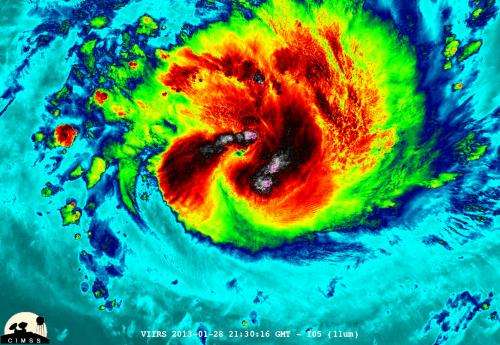
NASA satellite imagery revealed that Cyclone Felleng is packing some powerful thunderstorms with overshooting cloud tops.
An overshooting (cloud) top is a dome-like protrusion that shoots out of the top of the anvil of a thunderstorm and into the troposphere. It takes a lot of energy and uplift in a storm to create an overshooting top, because usually vertical cloud growth stops at the tropopause and clouds spread horizontally, forming an "anvil" shape on top of the thunderstorms.
During the night-time hours (Madagascar local time) of Jan. 28, NASA-NOAA's Suomi NPP satellite captured a night-time image of Cyclone Felleng when it was located northwest of Madagascar. The image was created at the University of Wisconsin-Madison and was false colored to reveal temperatures. The image showed some pretty cold overshooting cloud tops, topping at ~170K (-153.7F/ -103.1C). The image also showed some interesting gravity waves (waves in the atmosphere) propagating out from the storm in both the thermal (infrared) and visible imagery. The infrared imagery also showed that Felleng has strengthened significantly since the previous day as convective bands of thunderstorms are wrapping more tightly into the eye.
On Jan. 29, the MODIS (Moderate Resolution Imaging Spectroradiometer) instrument aboard NASA's Aqua satellite captured an image of Cyclone Felleng at 1015 UTC (5:14 a.m. EST) that showed strong thunderstorms around the center of circulation and a 22 nautical mile-wide-eye (25.3 mile/40.7 km) obscured by high clouds. The image clearly showed the western edge of the storm is approaching Madagascar.
Cyclone Felleng has continued to intensify, as NASA-NOAA's Suomi NPP image indicated with the identification of overshooting cloud tops. On Jan. 29 at 1500 UTC (10 a.m. EST), Felleng has maximum sustained winds near 90 knots (103.6 mph/166.7 kph). Felleng was located near 14.3 south latitude and 54.6 east longitude, about 420 nautical miles (483.3 miles/777.8 km) north of La Reunion. Felleng is moving west-southwestward at 8 knots (9.2 mph/14.8 kph).
On Jan. 30, a trough (elongated area) of low pressure is expected to turn Felleng southward. The storm is expected to continue intensifying as it moves parallel to the eastern coast of Madagascar.
Provided by NASA's Goddard Space Flight Center


