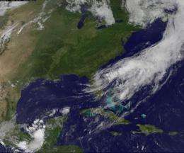
Debby now exiting Florida's east coast, disorganized on satellite imagery

Debby has tracked across Florida from the Gulf coast to the Atlantic coast, and the interaction with land has taken its toll on the storm's organization. In GOES-13 satellite imagery today, June 27, the bulk of clouds and showers associated with Debby are now over the Atlantic Ocean and Debby's circulation center is seen exiting the state and moving into the Atlantic Ocean.
Whenever a storm moves over land it encounters friction, that weakens it. It is also cut off from its power source of warm waters, adding to that weakening. That's what happened to Debby over the last day as it moved towards the Atlantic coast.
Debby has left a legacy of flooding in its wake. Many areas of northern Florida have received up to 10 inches of rain, with higher totals in isolated areas. Even sections of Florida's main east-west highway, Interstate 10, was shut down due to flooding.
On Wednesday, June 27, 2012 at 5 a.m. EDT (0900 UTC), Debby's maximum sustained winds were near 35 knots (55 kmh). It was located about 25 miles (45 km) southeast of St. Augustine, Florida, near latitude 29.6 north and longitude 81.0 west. Debby is moving east-northeast near 10 mph (17 kmh) and is expected to continue in this direction over the next couple of days while speeding up. Debby should gradually move away from Florida today, according to the National Hurricane Center.
A visible image of Tropical Depression Debby was taken from NOAA's GOES-13 satellite on Wednesday, June 27 at 8:31 a.m. EDT. It showed that t bulk of Debby's clouds and showers were over the Atlantic and coupled with a frontal system as Debby's center is now moving off the eastern shore of Florida. NOAA manages the GOES-13 satellite and NASA's GOES Project at the NASA Goddard Space Flight Center in Greenbelt, Md. uses the data to create images and animations.
The National Hurricane Center noted that some re-strengthening is possible as the system moves to the northeast and away from Florida.
Provided by NASA's Goddard Space Flight Center


