NASA sees Otto become eighth hurricane of the Atlantic season

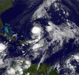
At 11 a.m. EDT on Oct. 8, Otto strengthened into a hurricane, becoming the eighth hurricane of the Atlantic Ocean season. NASA's Aqua satellite and the NOAA GOES-13 satellite captured images of Otto as he intensified.
Otto had maximum sustained winds near 75 mph, and the National Hurricane Center in Miami, Fla. noted that some strengthening is possible before it weakens on Saturday, Oct. 9. Otto was located about 445 miles south of Bermuda near 25.9 North and 64.0 West. It was moving east-northeast near 17 mph, and had a minimum central pressure of 979 millibars.
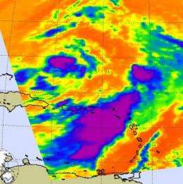
On Oct. 7 at 1729 UTC (1:29 p.m. EDT) NASA's Aqua satellite passed over Otto and the Atmospheric Infrared Sounder (AIRS) instrument captured an infrared image of its cloud temperatures. The image showed that the highest, coldest thunderstorm cloud tops colder than -65 Fahrenheit were around Otto's center and throughout the large band of strong thunderstorms extending from the southeast of Otto's circulation. That band of strong thunderstorms brought heavy rainfall on the already soaked areas of the northern Leeward Islands, the Virgin Islands, and Puerto Rico.

This morning, Otto developed a well-defined center, covered by dense overcast. There's a large curved band of showers and thunderstorms over the southeastern quadrant which continues to bring the heavy rainfall to the northern Leeward Islands, Virgin Islands, Puerto Rico and Dominican Republic today.
That large band of showers and thunderstorms extending from Otto's southeastern quadrant was apparent on infrared imagery from the Geostationary Operation Environmental Satellite, GOES-13 early today at 0245 UTC (10:45 p.m. EDT on Oct. 7).GOES satellites are operated by NOAA, and images and animations of GOES satellite data are created by the NASA GOES Project at NASA's Goddard Space Flight Center, Greenbelt, Md.
Because Hurricane Otto is expected to remain in an environment with light wind shear and warm waters for about 24 hours (until 11 a.m. EDT Saturday, Oct. 9), it is expected to strengthen during that time. After mid-day Saturday (eastern daylight time) Otto will run into increasing winds shear from the southwest and it will move into cooler waters. Sea surface temperatures of at least 80 degrees Fahrenheit are needed to maintain a tropical cyclone (hurricane).
Over the weekend as Otto weakens it will begin transition into an extratropical storm.
Provided by NASA's Goddard Space Flight Center


