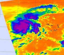
NASA infrared imagery sees tropical depression 14 becomes 12th tropical storm: Lisa

This Atlantic hurricane season has now spawned 14 tropical depressions and 12 of them have strengthened into tropical storms. The latest is now called Tropical Storm Lisa and is in the Eastern Atlantic Ocean. NASA's Aqua satellite flew over Lisa when she was still a low pressure area, but showed a center of circulation and banding of thunderstorms circling it, indicating the storm was getting organized.
The Atmospheric Infrared Sounder (AIRS) instrument that flies aboard NASA's Aqua satellite captured "Lisa" when she was still a low pressure area yesterday, Sept. 20 at 15:05 UTC (11:05 a.m. EDT). AT that time, infrared imagery showed the strongest convection, highest thunderstorms and heaviest rainfall were concentrated in the system's center and there were bands of thunderstorms surrounding the center. Those cloud top temperatures were as cold as -94 Fahrenheit (-70 Celsius), indicating strong thunderstorms. AIRS data indicated that overnight, those cloud top temperatures cooled. That indicates that the thunderstorms that are powering Lisa are higher, colder and stronger than they were yesterday. Infrared imagery helped forecasters see that Tropical Depression 14 became better organized and that it had become a tropical storm. Satellite imagery also showed that bursts of deep convection are forming near Lisa's circulation center.
At 5 a.m. EDT on Sept. 21, Tropical Depression 14 strengthened into Tropical Storm Lisa with maximum sustained winds near 40 mph. Lisa is in the Eastern Atlantic Ocean, about 530 miles west-northwest of the Cape Verde Islands near 17.7 North and 31.8 West. Lisa is moving north near 5 mph and is expected to turn to the north-northwest tomorrow, and then west-northwest on Thursday. The National Hurricane Center in Miami, Fla. noted that some strengthening is possible. Lisa's minimum central pressure is 1005 millibars.
Because Lisa is in an environment with low wind shear, it will allow her to strengthen further. Lisa will remain far at sea for now.
Provided by NASA's Goddard Space Flight Center


