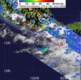
TRMM satellite sees Darby's remnants still kicking up isolated showers

A trough is an elongated area of low pressure and that's what the remnants of the once major hurricane known as Darby are becoming today. On June 28 at 6:55 p.m. EDT NASA and the Japanese Space Agency's Tropical Rainfall Measuring Mission (TRMM) satellite captured isolated areas of rainfall off the western Mexico coast from Darby's remnants.
The center of Darby the remnant low pressure area is located near 15 North and 97.5 West. Those remnants are still showing some scattered moderate to strong convection (rapidly rising air that creates clouds and thunderstorms) southwest of its center. Isolated strong convection likely associated with a nearby tropical wave is also being seen over the Gulf of Tehauntepec and within 60 nautical miles of the Mexican coast between 98 West and 101 West.
Darby's remnants still have southwest to westerly winds between 20 and 25 knots (23-28 mph). The National Hurricane Center noted that "Darby should weaken to an open trough later today then extend northwest to Caribbean Tropical Storm Alex. The trough will move northwest in tandem with Alex over the next few days."
Provided by NASA's Goddard Space Flight Center


