Tubewells to the rescue

The next day we went out again for resistivity and augering. Céline picked out two alternative sites that might be drier. We drove through the abandoned valley to the site. We took the direct route and found the local road to be in a terrible state of disrepair. The vans could barely make it through. Then we hit a spot where slumping off each side of the road narrowed it too much. The villagers helped make a temporary road with bricks and wood, but it was still too narrow. Then they filled a sandbag and together with the bricks, wood and other handy items we got across. It turned out that since the Upazila (county) voted for the opposition party, they have not had their roads repaired for over a decade. This level of politicization of everything in Bangladesh really hurts the country. When we reached the location of the line, we found that ponds between the road and the fields limited our access. We walked around and found a site next to a brick factory. The line was along an irrigation ditch. Fine to walk on either side, but submerged to mid-shin in you stepped in the middle. The data looked very good after processing. We may have found the top of the Pleistocene as relatively shallow depths consistent with the site being the top of a buried anticline (folded hill).
The delays from the bad road, site searching, and a longer distance to lug the equipment meant that we couldn't do augering. We came to the conclusion that we have to alternate days of resistivity and drilling. Not enough time in a day to do both properly. That meant the next day was for augering. We went back to the soccer field site, officially BNGTi1, and started augering with all six of us. We hurried past the section we had already described. To minimize hole collapse, we switched between two augers and tried to work quickly on the descriptions. It took all of us all morning to make it to 4.8 meters. The mud was too hard. We needed to go to plan B. We would drill tube wells and sample inside the wells. Alamgir and Basu went off to the village to find a driller. The rest of us cleaned off the equipment and ourselves at a nearby pond and well and had lunch. After several attempts, they found a driller, but he couldn't come until 3pm. I like to use all the available time I have here, but we now had a few hour break.
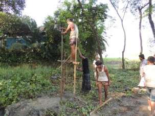
The three-person drill team arrived right at 3, unusual in this part of the world. I have seen the drilling technique before, but never the initial set up. In 20 minutes they set two vertical bamboo pole in the ground, tied on the cross piece to make a large H, attached a lever arm and the drill pipe, dug a mud pit for water and a channel to the actual well location. Then they started drilling. It was so much faster and easier than augering! In 10-20 minutes they were past the depth we reached. We don't get continuous sampled described every 10 cm (4 in), but the lithology averaged every 5 ft. Muds come up as solid cylinders that we collect, sands as a slurry that we decant. We subdivide the 5 ft. sections if there is a lithology change. The driller caught on quickly to what we wanted and kept us informed of all changes in sediment type, which he could easily feel. Céline and Basu, and experienced logger of tube wells did most of the sediment work, with some help from the rest of us. As expected, the section was primarily mud with some silt. We reached the sands from the abandoned channel at 42 ft., a little deeper than I expected but reasonable. It was still earlier enough for us to do another. Alamgir and I scouted a second location as they finished and packed up the equipment. We completed that one, with the sands at only 20 ft. North of our transect looks like there was an island splitting the channel in two. Here, which would have been downstream of the island, so we expected it to be shallow. Finally, things were going well. Using tubewells we should have plenty of time to drill several stratigraphic wells and then pick one for sampling. We celebrated with dinner at the local Chinese restaurant.
-
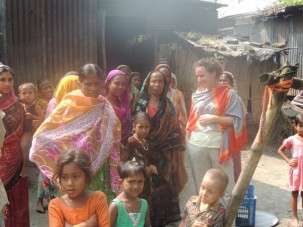
Céline watches the repair with some of the village women -
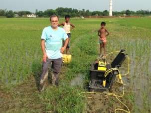
Standing ankle deep in mud by the resistivity meter. The smokestack of the brick factory can be seen in the distance. -
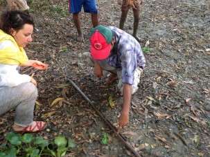
Céline and Basu describe the core brought up in the half-circle auger gouge. -
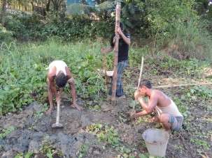
The three-person drill team preparing the site. Digging a post hole with rebar, inserting the bamboo pole and digging the mud pit with a kudali. -
The driller standing on the frame uses his palm to keep a seal on the pipe as the lever is used to lift and drop the drill pipe. On the fall, the mud come squirting out of the pipe.
Provided by Earth Institute, Columbia University


