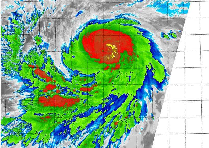
Suomi NPP satellite sees rapidly intensifying Hurricane Jimena

NASA-NOAA's Suomi NPP satellite flew over Hurricane Jimena in the Eastern Pacific and saw the strongest thunderstorms building up quickly, especially in the northern quadrant of the storm. Jimena intensified rapidly overnight on August 27 and early August 28 and the National Hurricane Center expects it to become a major hurricane.
The Visible Infrared Imaging Radiometer Suite or VIIRS instrument aboard the satellite provided infrared data of the storm that showed the coldest cloud top temperatures, which indicate the strongest thunderstorms were in Jimena's northern quadrant. Cloud top temperatures there were colder than -63 Fahrenheit (-53 Celsius).
VIIRS is a scanning radiometer that collects visible and infrared imagery and "radiometric" measurements. Basically it means that VIIRS data is used to measure cloud and aerosol properties, ocean color, and ocean and land surface temperatures.
Forecaster Berg at the National Hurricane Center (NHC) noted that microwave data has shown an eye beneath the central dense overcast, and a more definitive eye is just now becoming apparent in infrared satellite imagery.
At 11 a.m. EDT (8 a.m. PDT)/1500 UTC on August 28, the center of Hurricane Jimena was located near latitude 12.4 North and longitude 122.0 West. That puts the center about 1,075 miles (1,720 km) southwest of the southern tip of Baja California, Mexico.
Jimena was moving toward the west near 12 mph (19 kph), and this motion is expected to continue through early Saturday, August 29. The estimated minimum central pressure is 979 millibars.
The NHC noted that Jimena has been rapidly intensifying, and maximum sustained winds had increased to near 90 mph (150 kph) with higher gusts. Additional strengthening is forecast during the next 48 hours, and Jimena is expected to become a major hurricane tonight, August 28.
A peak intensity is expected in about 48 hours, when NHC expects Jimena's maximum sustained winds to reach 145 mph (125 knots), making it a powerful Category 4 hurricane on the Saffir-Simpson Scale. Thereafter, Jimena will gradually weaken due to a slightly drier environment and lower oceanic heat content values.
Provided by NASA's Goddard Space Flight Center


