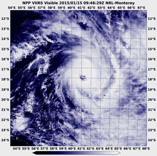
Suomi NPP Satellite sees Tropical Cyclone Bansi's eye almost quadruple in area

Tropical Cyclone Bansi reached Category 4 hurricane status earlier this week and developed an eye. As the storm weakened to a Category 2 storm on Jan. 14 the eye became cloud-filled. When NASA-NOAA's Suomi NPP satellite passed over on Jan. 15, the storm re-strengthened back to a Category 4 and the eye was again visible and almost quadrupled in width.
NOAA-NASA's Suomi NPP satellite passed over Tropical Cyclone Bansi on Jan. 15 at 09:46 UTC (4:46 a.m. EST) as it continued moving through the Southern Indian Ocean and the Visible Infrared Imaging Radiometer Suite (VIIRS) instrument image revealed the storm's re-opened eye. The Joint Typhoon Warning Center noted that animated multispectral satellite imagery revealed that the storm quickly re-consolidated and the eyewall became more defined and symmetric. The eye had also grown from 12 nautical miles (13.8 miles. 22.2 km) to 46 nautical miles (53.9 miles/85.1 km) wide.
Regional warnings were still in effect, but only in Rodrigues. A tropical cyclone warning class 3 was in effect at Rodrigues, while the warnings in Mauritius had been dropped.
At 0900 UTC (4 a.m. EST), Tropical cyclone Bansi had maximum sustained winds near 120 knots (138.1 mph/222.2 kph). Hurricane-force winds extend 40 nautical miles (46 miles/74 km) from the center, while tropical storm-force winds extend as far as 130 nautical miles (149.6/240.8 km) from the center.
Bansi was centered near 18.0 south latitude and 60.7 east longitude, about 230 nautical miles (264.7 miles/426 km) east-northeast of Port Louis, Mauritius. Bansi is moving to the east-southeast at 6 knots (6.9 mph/11.1 kph) and is expected to continue moving in that general direction.
As Bansi moves away from Rodrigues Island over the next two days it is expected to strengthen even more, with maximum sustained winds forecast to reach a Category 5 status on the Saffir-Simpson Scale at 145 knots (166.9/268.5 kph) before weakening again over open waters of the Southern Indian Ocean.
Provided by NASA's Goddard Space Flight Center


