Dr. Chris Okubo discusses the most detailed geologic map of Mars
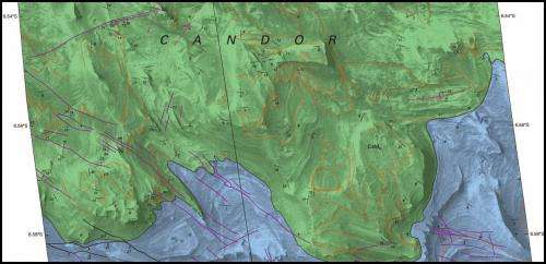
Earlier this month, the U.S. Geological Survey (USGS) released its highest-resolution geologic map of Mars. The new geologic and structural map uses the highest-resolution, orbiter-based images currently available for Mars – data from the High Resolution Imaging Science Experiment (HiRISE) camera on board NASA's Mars Reconnaissance Orbiter (MRO) – to illuminate past geological processes in a portion of "Grand Canyon of Mars" - Valles Marineris. The area analyzed, called western Candor Chasma, is one of the largest canyons in the Valles Marineris canyon system. In an interview with astrowatch.net, USGS scientist and map author Dr. Chris Okubo, describes his latest creation and the importance of map-making for future Mars missions.
Astrowatch.net: How much work does it take to create so much detailed geologic map?
Chris Okubo: Creating these types of maps starts with finding places on Mars that show key timing relationships between geologic units and structures. Then, these areas are entered into the targeting database for HiRISE. This can take about a week (5 days X 8 hours/day). Once these images are acquired by HiRISE, they need to be processed in order to generate a digital elevation model (DEM). The DEM then needs to be manually edited. This takes about 10 days. All of the data are then incorporated into the Geographic Information System (GIS), in this case ArcMap, and then the mapping can begin. Mapping takes about 40 days. After that, there's various peer reviews and revisions. This takes about 20 days of work over about 6 months to a year of back and forth. In all, it can take about 2 years from beginning to end.
Astrowatch.net: Why did you choose Candor Chasma region?
Okubo: I chose the Candor Chasma region because it contains many clear exposures of the bedrock and other structures such as faults and folds. Previous mapping using Viking data had also shown that this area contains numerous geologic units, spanning most of Mars' geologic history. So these rocks offer information on geologic processes that occurred throughout Mars' history. More recent observations by the CRISM (Compact Reconnaissance Imaging Spectrometer for Mars) instrument on MRO indicated that these sediments show chemical evidence of past groundwater.
Therefore understanding the geologic history of this area would also be helpful in characterizing past habitable environments on Mars. So lots of interesting details of Mars' geologic history can be gained by studying Candor Chasma.
Astrowatch.net: Do you plan to create the maps of other regions?
Okubo: I'm finishing up work on three other maps of west Candor Chasma, and starting work on three other maps in east Candor Chasma. All of these maps use HiRISE data and would be similar in scale to the Candor Colles map that was just published. In the future, I'd like to create detailed maps of west and east Candor Chasma at smaller scales (less detail) than the Candor Colles map. Creating a map at the scale of the Candor Colles map for all of Candor Chasma would require complete HiRISE coverage of Candor Chasma. We don't have complete HiRISE coverage, and doing so would probably require another decade or more of data collection by HiRISE. So if HiRISE goes long enough, there may be sufficient data for a high-resolution map in the future.
But, as a next step, there is already enough data (from HiRISE supplemented by lower-resolution data from the CTX camera) to create chasa-wide maps at smaller scales, but still with more detail than existing maps. This is why picking locations for the highest resolution HiRISE based maps is important - these maps need to be made at key areas that provide sufficient fundamental information of the local geology that these results can be extrapolated to areas with ONLY lower resolution data coverage (CTX).
Astrowatch.net: Can we say that HiRISE has revolutionized our way of mapping Mars, providing such a high-detailed imagery?
Okubo: Yes. As this map demonstrates, the HiRISE data has sufficient resolution to enable mapping at the human scale. Previous orbiter-based imaging data sets could not come close to this level of detail. This level of detail is necessary to resolve geologic structures that are ambiguous at lower resolutions. A good example of this are the fault zones and injectites megapipes in the Candor Colles map. The fault zones were previously interpreted as volcanic dikes and the megapipes were indistinguishable from other hills and knobs in previous images. The high resolution of the HiRISE data and the derived DEMs enable measurements of orientations of bedding and faults, as well as superposition relationships, that are necessary to determine their true nature.
Astrowatch.net: What was the most difficult part of creating this new map?
Okubo: The most difficult aspect is tracing out all of the structures and then figuring out whether the structures are faults or unconformities. There are hundreds of mapped structures, and each takes careful examination to determine their nature and to ensure they are mapped accurately.
Astrowatch.net: Your maps would come in handy for future Mars missions, maybe manned, what can we learn from USGS maps of the Red Planet?
Okubo: Maps such as this one can reveal geologically-interesting areas on Mars that could be targets for future exploration. For example, these high-resolution maps can show where past groundwater existed. These areas would be of interest for future missions whose goal is to investigate potentially-habitable environments and look for evidence of past life, such as microfossils. These maps can also be used to show where small amounts of water may exist in the present day. Recurrent slope lineae (RSL) are features that other researchers have discovered using HiRISE data. These researchers suggest that these features form through the movement of small amounts of water in the subsurface. Creating high-resolution geologic maps of these RSL areas may help to provide new information on how they form. One of my future map areas in east Candor Chasma will focus on an area that contains RSL.
Astrowatch.net: Could you develop even more detailed map of Mars in the future?
Okubo: Higher resolution maps would require data taken from much closer to the ground, such as from a rover. Rover-based maps are being generated by other scientists using data from the Mars Exploration Rovers Spirit and Opportunity, as well as the Curosity rover for areas along the rovers' traverses in Gusev crater, Meridiani Planum, and Gale crater respectively. I'm planning to stick to HiRISE-based mapping because HiRISE images all over the planet and, as you can see, this can give us an incredible amount of information for many, many areas around Mars, for which there are no landed vehicles currently.
I would like to encourage the public to participate in the exploration of Mars by suggesting targets for the HiRISE camera to image. Just visit www.uahirise.org/hiwish.
More information: The high-resolution USGS map is available at: pubs.usgs.gov/sim/3309/
Source: Astrowatch.net


