NASA satellite sees a somewhat lopsided Typhoon Halong

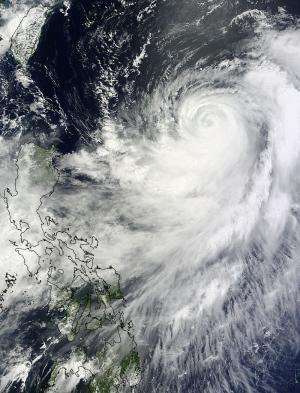
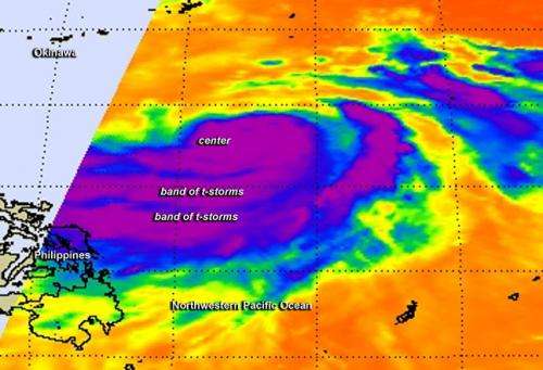
Infrared satellite imagery from NASA shows bands of powerful thunderstorms around Typhoon Halong's center, southern and eastern quadrants, while the northern quadrant is lacking in them. Typhoon Halong appears somewhat lopsided on satellite imagery because thunderstorm development in the northern side of the storm is being inhibited.
When NASA's Aqua satellite passed over Typhoon Halong on Aug. 4 at 12:47 a.m. EDT, the Atmospheric Infrared Sounder (AIRS) instrument aboard provided infrared data on the cloud top temperatures of Typhoon Halong. AIRS data showed powerful thunderstorms with the highest, coldest cloud tops circled the center of the storm and were in two thick bands in the southern and eastern quadrants of the storm. Cloud top temperatures exceeded -63F/-52C indicating they were nearing the top of the troposphere. NASA research has shown that cloud top temperatures that cold, from storms that high, have the potential to produce heavy rainfall.
The other thing that the infrared imagery showed was a degradation of strong convection and thunderstorm development in the northern half of the storm. The Joint Typhoon Warning Center noted that development is being inhibited because of subsidence, that is, the sinking of air (from above). In order for thunderstorms to form, air needs to rise and condense into clouds. When air is sinking from overhead, it prevents cloud formation from happening.
On Aug. 5 at 02:15 UTC, the MODIS instrument aboard NASA's Terra satellite captured a visible image of Typhoon Halong in the western Pacific Ocean that showed the strongest bands of thunderstorms continued to be in the southern and eastern quadrants of the storm.

At 1500 UTC (11 a.m. EDT) Halong's center was located near 21.4 north latitude and 130.1 east longitude, about 351 nautical miles (403.9 miles/ 650.1 km) south-southeast of Kadena Air Base, Okinawa. Maximum sustained winds were near 85 knots (97.8 mph/157.4 kph). Halong continues to generate extremely rough seas with maximum significant wave heights at 35 feet (10.6 meters).
JTWC forecasters expect Halong to continue moving north-northeast over the next day or two before taking a more northerly track toward mainland Japan.
Provided by NASA's Goddard Space Flight Center


