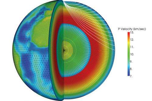
3-D Earth model more accurately pinpoints explosions

During the Cold War, U.S. and international monitoring agencies could detect nuclear tests and measure their size. Today, they seek to pinpoint much smaller explosives tests. Under the sponsorship of the National Nuclear Security Administration's Office of Defense Nuclear Nonproliferation R&D, Los Alamos and Sandia National Laboratories (SNL) have partnered to develop a 3-D model of the Earth's mantle and crust called SALSA3D (Sandia-Los Alamos 3D). The purpose of this model is to assist the U.S. Air Force and the international Comprehensive Nuclear Test Ban Treaty Organization (CTBTO) in Vienna, Austria, with more accurately locating all types of explosions.
Significance of the research
After an explosion, the energy travels through the Earth as waves that seismometers at U.S. and international ground stations associated with nuclear explosion monitoring organizations detect. Scientists use these signals to determine the location of the explosion. The scientists first predict the time taken for the waves to travel from their source through the Earth to each station. To calculate that, they must know the seismic velocity of the Earth's materials from the crust to the inner core. If the energy travels through material with low seismic velocity, it takes signals longer to travel from the explosion's source to the receiver.
In the past 100 years, seismologists have predicted the travel time of seismic energy from source to receiver using one-dimensional models. However, these models do not do well at predicting travel time to nearby events where the waves spend most of their time in the Earth's crust or the shallowest parts of the mantle, both of which contain a larger variety of materials than the lower mantle and the Earth's core. Therefore, the largest errors occur close to the surface of the Earth where the most variability in materials exists.
SALSA3D and improved predictive accuracy
SALSA3D accounts for distortions of the seismic wavefronts caused by minor differences in the properties of rock and other materials. For example, waves are distorted when they move through a subduction zone, such as the one beneath the west coast of South America where one tectonic plate under the Pacific Ocean dives underneath the Andes Mountains. In recent tests, SALSA3D predicted the source of seismic events over a geological area that was 26 percent more accurate than the traditional one-dimensional model. Monitoring agencies could use SALSA3D to precompute the travel time from each station in their network to every point on Earth.
Research achievements
LANL's role is the data accumulation from the ground-based nuclear detonation detection research database for ground-truth events (seismic events where we know the location to some specific uncertainty, called LOCDB or location database), the associated paths to various seismic stations, collaboration on the tomographic process and the validation of the 3-D model for seismic location accuracy. Los Alamos provides Sandia the data to use for the tomography model (approximately ten million ray paths from approximately 13,000 distinct seismic stations and approximately 122,000 distinct events), Sandia runs their tomography code to produce the 3-D velocity model and then LANL takes the final model and runs tests to validate how well the model performs.
Provided by Los Alamos National Laboratory


