Wind shear and dry air bashing Tropical Depression Sonamu

Once a cyclone, now a tropical depression, Sonamu is being battered by moderate wind shear and an intrusion of dry air is it has practically stalled in the South China Sea.
On Sunday, Jan. 6, Tropical Storm Sonamu's maximum sustained winds were near 40 knots (46 mph/74 kph). Sonamu's center was located about 255 nautical miles (258.9 miles/416.7 km) southeast of Ho Chi Minh City, Vietnam, near 7.2 north and 108.9 east and continued to move west. At that time, the ragged low level center became exposed to outer winds. Satellite data showed that the strongest convection and heaviest rainfall was now pushed to the north because of wind shear.
On Monday, Jan. 7, Sonamu was curving to the southwest and is now expected to miss the Malay Peninsula. The Malay Peninsula contains the southernmost tip of Myanmar, Peninsular Malaysia, Singapore, and Southern Thailand. Sonamu is now expected to continue slowly on a southerly track.
Sonamu's maximum sustained winds are down to 30 knots (34.5 mph/55.5. kph). At 1500 UTC (10 a.m. EST/U.S.), Sonamu was located near 6.1 north latitude and 108.3 east longitude, about 290 nautical miles (333.7 miles/537.1 km) south-southeast of Ho Chi Minh City, Vietnam. Sonamu is crawling to the southwest at 1 knot (1 mph/1.8 kph). Sonamu is battling moderate wind shear, which is weakening the storm.
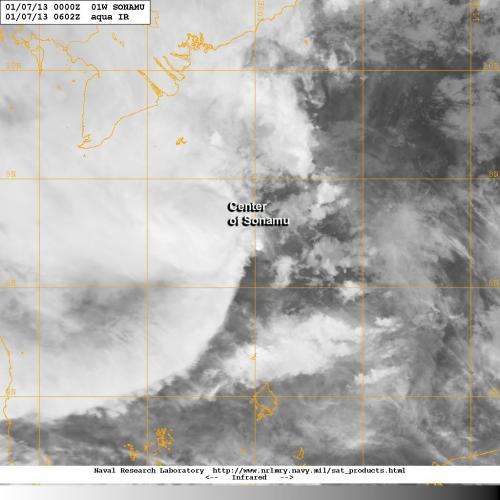
NASA's Aqua satellite passed over Sonamu on Jan. 7 and noticed that the eastern half of the storm was almost devoid of clouds and showers, which is an effect of the dry air intrusion. The Moderate Resolution Imaging Spectroradiometer captured an infrared image of the storm that showed the bulk of the cloud cover was west of the center.
According to the Joint Typhoon Warning Center on Jan. 7, infrared imagery shows a rapidly deteriorating, partially exposed low level circulation center with flaring convection along the western edge of the storm. Water vapor imagery indicated a pocket of dry air is wrapping along the eastern half of the low-level center toward Sonamu's center. Dry air saps convection, which forms the thunderstorms that make up a tropical cyclone.
Forecasters at the Joint Typhoon Warning Center expect that the combination of wind shear and dry air will lead to the dissipation of Sonamu over the next couple of days in the South China Sea.
Provided by NASA's Goddard Space Flight Center


