NASA catches small area of heavy rain in fading Tropical Depression 25W

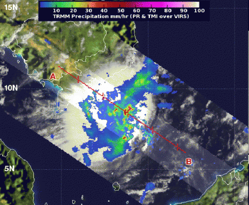
Tropical Depression 25W was raining on southern Vietnam on Nov. 14 when NASA's TRMM satellite passed overhead and measured rainfall rates within the storm. TRMM noticed that the heaviest rainfall was limited to a small area and was located over open waters.
NASA's TRMM or Tropical Rainfall Measuring Mission satellite was launched in 1997, and can read that rate at which rain falls in storms on Earth from its orbit in space. NASA's TRMM satellite flew over Tropical Depression 25W on Nov. 14 at 0133 UTC and captured rainfall rate data. The TRMM data showed a small area of heavy rainfall away from the center of circulation, where rain was falling at 2 inches/50 mm per hour over the open waters of the South China Sea. Rainfall throughout the rest of the storm was light to moderate.
TRMM also provides cloud height estimates. The height of thunderstorms within a tropical cyclone is related to their strength. The higher the thunderstorms, the stronger they are, and the more likely they have heavier rainfall rates. When TRMM passed over TD25W, the data showed some thunderstorms as high as 10 kilometers (6.2 miles). As TD25W continued interacting with land, however, those cloud heights likely fell.
On Nov. 14 at 1800 UTC (1 p.m. EDT), the Joint Typhoon Warning Center issued their final advisory on TD25W as it was moving over southern Vietnam. At that time, TD25W's maximum sustained winds were near 25 knots (28.7 mph/46.3 kph) and weakening as a result of wind shear and land interaction. The depression was centered near 8.7 North latitude and 107.2 East longitude, about 148 nautical miles (170 miles/274 km) south-southeast of Ho Chi Minh City, Vietnam. TD25W was moving to the west-northwest at 13 knots (15 mph/24 kph).
Satellite imagery captured after TRMM's early morning overpass revealed that the bulk ofTD25W's rainfall was being pushed to the northwest as a result of strong southeasterly wind shear.
By Nov. 15 at 11 a.m. EDT (1600 UTC), most of the remnant rainfall from Tropical Depression 25W had moved over the Andaman Sea. The depression's center had elongated from north to south as the storm continued to weaken. At that time, some rainfall from the storm's northern extent was occurring over Yangon, Burma.
Tropical Depression 25W is expected to dissipate later on Nov. 15 over the Andaman Sea.
Provided by NASA's Goddard Space Flight Center


