NASA Global Hawk and satellites attend Tropical Storm Nadine's 'Birth'

Tropical Depression 14 strengthened into Tropical Storm Nadine while NASA's Hurricane Severe Storm Sentinel Mission, or HS3 mission, was in full-swing and NASA's Global Hawk aircraft captured the event. While the Global Hawk was gathering data over the storm, NASA satellites were also analyzing Nadine from space.
NASA's Global Hawk landed back at Wallops Flight Facility, Wallops Island, Va., after spending a full day gathering data from the 14th Atlantic Tropical Depression that strengthened into Tropical Storm Nadine during the morning hours of Sept. 12.
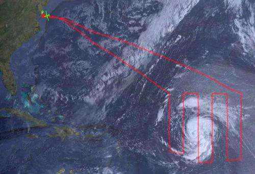
The Global Hawk, one of two associated with the HS3 mission, sought to determine whether hot, dry and dusty air associated with the Saharan air layer was being ingested into the storm. This Saharan air typically crosses westward over the Atlantic Ocean and potentially affects tropical cyclone formation and intensification. During its 26 hour flight around Nadine, the Global Hawk covered more than 1 million square kilometers (386,100 square miles) going back and forth over the storm in what's called a "lawnmower pattern." The Global Hawk captured data using instruments aboard and also dropping sensors called sondes into the storm. The dropsonde system ejected the small sensors tied to parachutes that drift down through the storm measuring winds, temperature and humidity.
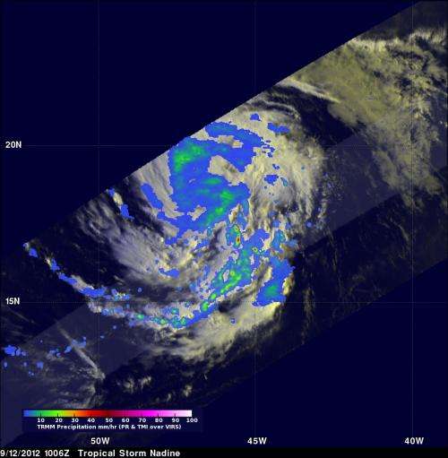
NASA's Tropical Rainfall Measuring Mission (TRMM) satellite passed over Tropical Storm Nadine on Sept. 12 at 1006 UTC (6:06 a.m. EDT) and captured rainfall rates occurring in the storm. Visible and infrared data were combined from TRMM's Visible and InfraRed Scanner (VIRS) instrument and TRMM's Microwave Imager (TMI) and Precipitation Radar (PR) instruments to create an image of Nadine's rainfall. Most of the tropical storm had light to moderate rainfall, falling at a rate between .78 to 1.57 inches/20 to 40 mm per hour. In the southeastern quadrant TRMM data revealed heavy rain was falling at a rate of 2 inches/50 mm per hour. The TRMM data was processed by the TRMM Team at NASA's Goddard Space Flight Center in Greenbelt, Md. TRMM is managed by both NASA and the Japanese Space Agency, JAXA.

NOAA's GOES-13 satellite provided a visible image of Tropical Storm Nadine at 1445 UTC (10:45 a.m. EDT). The image showed that Nadine was developing a central dense overcast and bands of thunderstorms all around the storm. Like the TRMM image, the GOES image was created at NASA Goddard, but made by the NASA GOES Project.
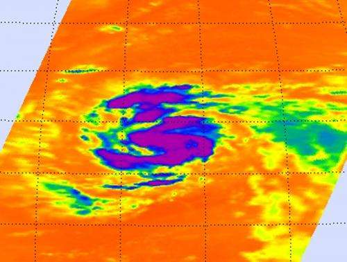
NASA's Aqua satellite also captured an image of Nadine. The Atmospheric Infrared Sounder (AIRS) instrument aboard Aqua captured an infrared image of Tropical Storm Nadine on Sept. 12 at 0441 UTC (12:41 a.m. EDT) that was created at NASA's Jet Propulsion Laboratory in Pasadena, Calif.
The AIRS image revealed that Nadine developed a signature comma shape. The AIRS image also showed that Nadine had a large area of strong thunderstorms surrounding the center of circulation and in a band south of the center, where cloud top temperatures exceeded the -63 Fahrenheit/-52 Celsius threshold, indicating strong thunderstorms with heavy rainfall, confirming the data from NASA's TRMM satellite.

On Sept. 11 at 1500 UTC (11 a.m. EDT), Tropical Storm Nadine had maximum sustained winds near 60 mph (95 kmh). The National Hurricane Center has forecast additional strengthening and expects Nadine to reach hurricane strength some time tonight, Sept. 12, or on Thursday, Sept. 13. Tropical storm force winds extend outward up to 115 miles (185 km) from the center, making Nadine about 230 miles (370 km) in diameter.
The center of Tropical Storm Nadine was located near latitude 19.1 north and longitude 47.6 west, about 940 miles (1,510 kilometers) east-northwest of the Lesser Antilles. Nadine is moving toward the west-northwest near 15 mph (24 kmh) and the National Hurricane Center expects Nadine to turn toward the northwest followed by a turn toward the north-northwest Thursday night. Nadine's estimated minimum central pressure is 997 millibars. Nadine is expected to remain in a favorable (weak) upper-level wind environment for the next couple of days.
The HS3 mission targets the processes that underlie hurricane formation and intensity change. The data collected will help scientists decipher the relative roles of the large-scale environment and internal storm processes that shape these systems.
HS3 is supported by several NASA centers including Wallops; Goddard; Dryden; Ames Research Center, Moffett Field, Calif.; Marshall Space Flight Center, Huntsville, Ala.; and the Jet Propulsion Laboratory, Pasadena, Calif. HS3 also has collaborations with partners from government agencies and academia.
HS3 is an Earth Venture mission funded by NASA's Science Mission Directorate in Washington. Earth Venture missions are managed by NASA's Earth System Science Pathfinder Program at the agency's Langley Research Center in Hampton, Va. The HS3 mission is managed by the Earth Science Project Office at NASA's Ames Research Center.
Provided by NASA's Goddard Space Flight Center


