This article has been reviewed according to Science X's editorial process and policies. Editors have highlighted the following attributes while ensuring the content's credibility:
fact-checked
trusted source
proofread
3D terrestrial laser scanner assists in reconstructing glacier's mass balance sequence

Complex topography of glacier surfaces under accelerating global warming presents unprecedented challenges to traditional methods of glaciological observation due to intense fragmentation and differential melting.
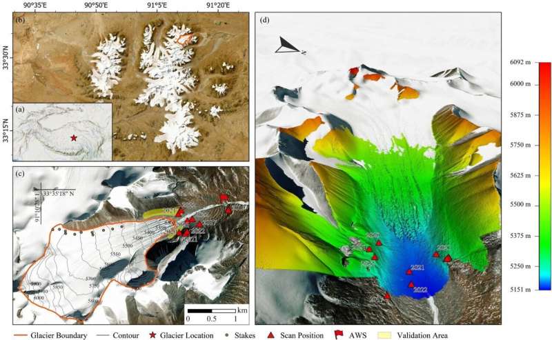
To address these challenges, Prof. Kang Shichang and his research team from the Northwest Institute of Eco-Environment and Resources of the Chinese Academy of Sciences adopted advanced Terrestrial Laser Scanner (TLS) technology to monitor the Ganglongjiama (GLJM) glacier in the headwaters of the Yangtze River for five years.
Results of the study, titled "An evaluation of TLS-based glacier change assessment in the central Tibetan plateau," were published in the International Journal of Digital Earth.
Researchers from the team achieved centimeter-level precision in documenting changes in the downstream area of the GLJM glacier using the Multiscale Model to Model Cloud Comparison (M3C2) algorithm. They reconstructed the glacier's mass balance sequence by integrating stake observation data and precipitation records.
The findings revealed a significant acceleration in the glacier's melting rate from 2017 to 2022, with the glacier terminus thinning by a total of 13.305 meters. The glacier's terminus continued to melt even during non-summer seasons, accounting for approximately 28% of the annual ice loss, the research found.
Furthermore, changes in supraglacial channels and lakes significantly intensified local melting and glacier frontal detachment. During the observation period, the glacier experienced a total negative mass balance of 2.58 meters water equivalent, with an equilibrium line altitude of approximately 5,800 meters above sea level.
This study highlights the potential of TLS technology in glacier observation, demonstrating its unique advantages in capturing detailed glacier changes. The high-precision glacier topography reconstructed by TLS technology enhances our understanding of glacier dynamics and provides valuable insights for predicting future glacier changes.
"Our next plans involve further exploring the quantitative analysis of glacier movement using point cloud data to accurately distinguish between glacier movement and mass balance," said Prof. Kang.
The team will aim to integrate TLS technology with Unmanned Aerial Vehicle (UAV) remote sensing data to obtain more comprehensive high-resolution glacier change data, according to Kang.
More information: Yuang Xue et al, An evaluation of TLS-based glacier change assessment in the central Tibetan plateau, International Journal of Digital Earth (2024). DOI: 10.1080/17538947.2024.2375527
Provided by Chinese Academy of Sciences


