This article has been reviewed according to Science X's editorial process and policies. Editors have highlighted the following attributes while ensuring the content's credibility:
fact-checked
trusted source
proofread
GOES-U satellite reaches geostationary orbit, now designated GOES-19

On July 7, 2024, NOAA's GOES-U executed its final engine burn, placing the satellite in geostationary orbit 22,236 miles above Earth's equator. Upon reaching this milestone, GOES-U was renamed GOES-19. GOES satellites are designated with a letter prior to launch and a number once they achieve geostationary orbit.
GOES-U launched on June 25, 2024, at 5:26 p.m. EDT, lifting off from Launch Complex 39A at NASA's Kennedy Space Center in Florida, aboard a SpaceX Falcon Heavy rocket. The launch was managed by NASA's Launch Services Program, based at Kennedy Space Center.
GOES-U separated from the SpaceX Falcon Heavy second-stage rocket at 9.56 p.m. EDT on June 25. Mission managers confirmed first-stage deployment of the spacecraft's solar array at 10:18 p.m., and the satellite began operating on its own power.
The Falcon Heavy rocket delivered GOES-U to a geostationary transfer orbit, a highly elliptical orbit where the satellite is close to the Earth during one part of its orbit and far from the Earth on the opposite side. Placing GOES-U in a geostationary transfer orbit provided the satellite a path to reach its final geostationary orbit over the equator (see diagram below). After a series of orbit-raising maneuvers and engine burns, on July 7, GOES-U was delivered into a circular geostationary orbit. The satellite is now in position to orbit at the same rate Earth rotates, so it can keep constant watch over the same region.
Next, GOES-19 will perform the second-stage deployment of its solar array. The deployed solar panels will form a single solar array wing that will rotate once per day to continuously point its photovoltaic (solar) cells toward the sun. The photovoltaic cells will convert energy from the sun into electricity to power the entire satellite, including the instruments, computers, data processors, sensors and telecommunications equipment.
-
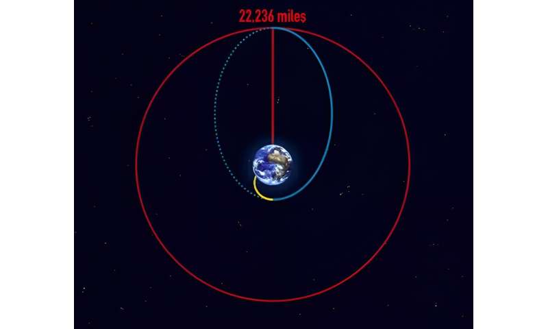
Geostationary transfer orbit: After liftoff, the launch vehicle makes its way to space following a path shown by the yellow line. At the target destination, the rocket releases the payload which sets it off on an elliptical orbit, following the blue line which sends the payload farther away from Earth. The point farthest away from the Earth on the blue elliptical orbit is called the apogee and the point closest is called the perigee. When the payload reaches the apogee at the geostationary altitude of 22,236 miles, it fires its engines in such a way that it enters onto the circular geostationary orbit and stays there, shown by the red line in the diagram. The geostationary transfer orbit is the blue path from the yellow orbit to the red orbit. Credit: The European Space Agency -
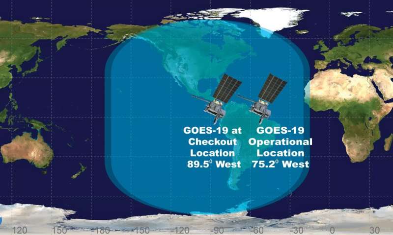
GOES-19's position and view over the Western Hemisphere at its checkout location and its operational location. Credit: NOAA Headquarters
In the days that follow, satellite operators will conduct several maneuvers to get GOES-19 to its 89.5 degrees west longitude initial checkout position, between the operational GOES-East and GOES-West satellites. Then, the magnetometer boom will be deployed. The satellite will then begin on-orbit checkout and validation of its instruments and systems.
NOAA expects to see the first images from GOES-19 in September. After completing post-launch check out, NASA will hand GOES-19 over to NOAA, which will validate the satellite's data products and drift GOES-19 to its operational position at 75.2 degrees west longitude. NOAA plans for GOES-19 to take over as the operational GOES-East satellite in April 2025, replacing GOES-16. GOES-16 will become the on-orbit standby satellite.
GOES-19 will track severe storms, hurricanes, wildfires, lightning, fog and other hazards that threaten most of North America, including the contiguous United States, Mexico, Central and South America and the Caribbean. The satellite will also monitor solar activity and space weather to provide early warnings of disruptions to power grids, communications, and navigation systems. Onboard GOES-19 is a new instrument, the Compact Coronagraph-1 (CCOR), which will support NOAA's Space Weather Follow On (SWFO) mission.
CCOR-1 will image the solar corona (the outer layer of the sun's atmosphere) and help detect and characterize coronal mass ejections (CMEs), large expulsions of plasma and accompanying magnetic field from the corona, which are the primary cause of geomagnetic storms. CCOR-1 will be the nation's first operational coronagraph and will serve as the primary source for information about impending geomagnetic storm conditions, allowing the Space Weather Prediction Center to issue warnings one to four days in advance.
Provided by NOAA Headquarters


