This article has been reviewed according to Science X's editorial process and policies. Editors have highlighted the following attributes while ensuring the content's credibility:
fact-checked
proofread
Satellite SAR and its role in heritage site protection in Europe and China

Remote sensing has long been a crucial tool in archaeology, with optical and radar imaging maturing significantly. However, detecting sub-surface features and monitoring heritage sites under various environmental conditions remain challenging.
Addressing these challenges necessitates advanced sensor data, high-performance computing, and automated analysis methods. Comprehensive research is essential to enhance archaeological prospection and heritage site protection.
A collaborative research effort between Wuhan University and the National Research Council of Italy, published in Geo-spatial Information Science, showcases the latest advancements in using Satellite Synthetic Aperture Radar (SAR) for archaeological prospection and heritage protection.
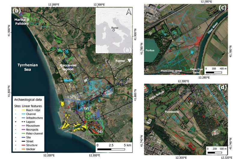
The study presents six demonstration use-cases across Italy, China, and Russia, including the Ostia-Portus area in Rome, Wuhan, the Jiuzhaigou National Park, and the Siberian "Valley of the Kings." The research utilizes a mix of archive and newly tasked medium to very high-resolution SAR and optical imagery, combined with field-based evidence and auxiliary data.
Key findings include detecting buried structures in mixed land cover environments, identifying threats to cultural heritage from ground instability, and monitoring post-disaster impacts in natural reserves. For instance, SAR data in Ostia-Portus revealed significant buried features that traditional optical methods missed.
In Wuhan, the study highlighted urban development impacts on heritage sites and provided mitigation insights. SAR's all-weather capability, high spatial resolution, and ability to penetrate vegetation and soil make it a vital tool for archaeological prospection and heritage monitoring.
Dr. Francesca Cigna, lead author from the National Research Council of Italy, states, "This research exemplifies the transformative potential of satellite SAR in archaeology and heritage conservation. By integrating advanced SAR data with traditional methods, we can uncover hidden archaeological features and proactively protect our cultural heritage from environmental and human-induced threats."
The research findings significantly impact archaeology and heritage conservation. Using SAR technology to detect and monitor buried features, especially in challenging environments, enhances monitoring and protects heritage sites from natural disasters and urban development, ensuring their preservation for future generations. This study advances remote sensing applications and interdisciplinary approaches in heritage management.
More information: Francesca Cigna et al, Exploiting satellite SAR for archaeological prospection and heritage site protection, Geo-spatial Information Science (2023). DOI: 10.1080/10095020.2023.2223603
Provided by TranSpread


