This article has been reviewed according to Science X's editorial process and policies. Editors have highlighted the following attributes while ensuring the content's credibility:
fact-checked
proofread
Mapping the world's salted soils: A leap forward in combating land degradation

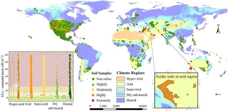
A team of researchers has developed an approach that maps the soil salt content around the world with an exceptional detail of 10 meters. This advance tackles the pressing need for accurate assessments of soil salinity, a formidable challenge that jeopardizes agricultural productivity and soil vitality on a global scale.
Soil salinity, a form of land degradation, affects over 1 billion hectares globally, compromising agricultural productivity and environmental health. Previous attempts at mapping soil salinity were hindered by the coarse spatial resolution of existing datasets and limitations in capturing the continuity of soil salinity content.
Recognizing these challenges, the research team embarked on developing a model that integrates Sentinel-1/2 images, climate data, terrain information, and advanced machine learning algorithms to estimate soil salt content across five climate regions. These findings were detailed in a study published on March 28, 2024, in Journal of Remote Sensing. This research introduces a device that skillfully integrates slanted spiral channels with periodic contraction-expansion arrays.
At the heart of this endeavor is the fusion of data from an array of remote sensing technologies, notably the advanced Sentinel-1/2 satellites, and the strategic application of machine learning algorithms. This approach has birthed a sophisticated model capable of delineating soil salinity with unprecedented precision—a 10-meter resolution across varying climates.
This methodological breakthrough propels us far beyond the limitations of past attempts, which were shackled by their coarser resolution and a narrower scope in salinity analysis. The dedicated research team has assembled an extensive dataset, capturing global climate patterns, precise ground-level soil salinity readings, and a comprehensive set of geospatial variables.
Employing the Random Forest algorithm, the model not only excels in predicting soil salinity with remarkable accuracy but also sheds light on the pivotal roles that climate, groundwater levels, and salinity indices play in the formation of soil salinity landscapes. This advance marks a step forward in our ability to monitor and manage soil health on a global scale.
Professor Zhou Shi, the lead researcher, stated, "This study marks a significant leap in our ability to assess and manage soil salinity at a global scale. By combining satellite imagery with machine learning, we can now identify saline soils with unprecedented accuracy and detail, offering valuable insights for sustainable land and agricultural practices."
The high-resolution global soil salinity map generated from this research provides an essential tool for scientists, policymakers, and farmers to address soil salinity issues effectively. It enables targeted interventions for soil health restoration, supports sustainable agricultural practices, and aids in resource management planning. The methodology also sets a new standard for environmental monitoring, potentially applicable to other land degradation assessments.
More information: Nan Wang et al, Global Soil Salinity Estimation at 10 m Using Multi-Source Remote Sensing, Journal of Remote Sensing (2024). DOI: 10.34133/remotesensing.0130
Provided by Journal of Remote Sensing


