This article has been reviewed according to Science X's editorial process and policies. Editors have highlighted the following attributes while ensuring the content's credibility:
fact-checked
proofread
Forecasts show growing El Niño event
. The SST anomalies are calculated based on the 1993–2016 average. The boxes show commonly used areas for which anomalies are forecast. Areas around islands are left blank. Credit: European Centre for Medium-Range Weather Forecasts (ECMWF)")
Forecasts assembled by the EU's Copernicus Climate Change Service (C3S) implemented by ECMWF predict a growing El Niño event this year.
An El Niño event is a prolonged period of abnormally high sea-surface temperatures (SST) in the tropical Pacific Ocean. It goes hand in hand with changes in atmospheric conditions and can have strong repercussions on global weather patterns. El Niño can also significantly affect the global average temperature and hence influence the global warming signal.
SST anomalies in the tropical Pacific are already above zero, and all forecasts included in the C3S seasonal multi-system predict that they will most likely continue to rise over the next few months. There is, however, still considerable uncertainty about how strong the event will be.
June forecasts
The El Niño–Southern Oscillation (ENSO) is an irregular oscillation in winds and sea-surface temperatures over the tropical Pacific Ocean. A three-year La Niña period, marked by relatively cool SST, gave way to neutral conditions earlier this year, and now the development of El Niño conditions is under way.
New forecasts based on data from eight organizations, including ECMWF, predict that SST anomaly values in the NINO3.4 region will most likely continue to go up over the next six months.
")
The forecasts from different centers show general agreement about the trend, although all of them show a considerable spread and the mean value also differs slightly between forecast systems.
May's update from the World Meteorological Organization (WMO) predicted a great chance of El Niño conditions increasing, and on 8 June the US National Oceanic and Atmospheric Administration (NOAA) said weak El Niño conditions had emerged.
Significance of El Niño events
An El Niño event temporarily increases global average 2-meter temperatures in the year after the peak of the event. That is why the WMO is saying that global temperatures will probably "surge to record levels" over the next few years.
Substantial El Niño events are also associated with significant changes in weather patterns, especially in areas close to the tropical Pacific. The eastward movement of the warming of surface waters in the tropical Pacific brings higher than average pressure and less rain to the western Pacific, and lower pressure and more rain to the eastern Pacific.
-
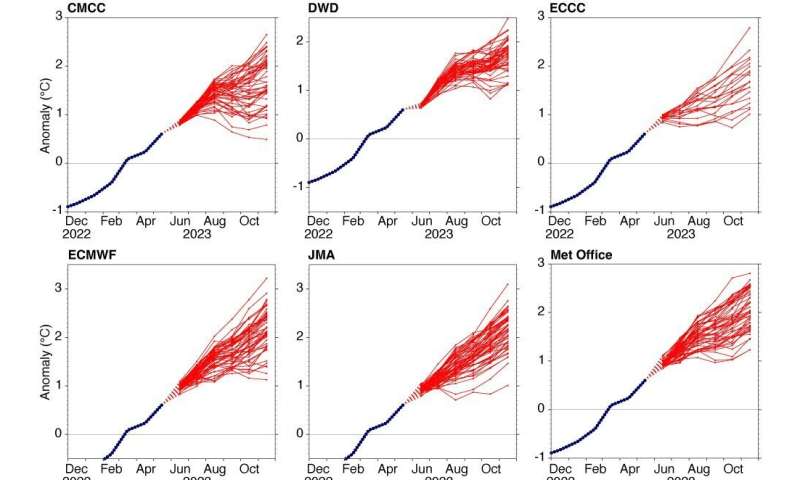
Individual SST anomaly forecasts for the NINO3.4 region from June 2023 according to the C3S website. The forecasts are from Italy’s Euro-Mediterranean Center on Climate Change (CMCC), the German Meteorological Service (DWD), Environment and Climate Change Canada (ECCC), ECMWF, the Japan Meteorological Agency (JMA), the UK Met Office, Météo-France and the US National Centers for Environmental Prediction (NCEP). Credit: European Centre for Medium-Range Weather Forecasts (ECMWF) -
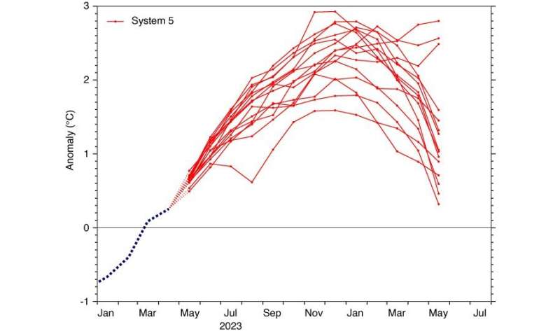
13-month NINO3.4 SST anomaly plume in an ECMWF forecast from 1 May 2023. The monthly mean anomalies are calculated relative to the 1981–2010 climatology. Credit: European Centre for Medium-Range Weather Forecasts (ECMWF)
El Niño events also contribute to other climate anomalies around the world. The specifics of the anomalies can differ from event to event, and the effects over Europe are particularly uncertain.
ECMWF also issues 13-month NINO3.4 anomaly forecasts on 1 February, May, August and November as part of its open access forecasts. The May forecast suggests that high values are likely to dissipate in the first part of next year, although it predicts a small chance that high anomalies will continue well into 2024.
Previous strong El Niños in 1997 and 2015 dissipated relatively quickly in the following year.
Provided by European Centre for Medium-Range Weather Forecasts (ECMWF)


