September 27, 2022 report
Zhurong rover finds evidence of possible flooding on Mars billions of years ago

A team of researchers at the Chinese Academy of Sciences, working with a colleague from Peking University, has found evidence of a layered subsurface in the Utopian Basin on Mars. In their paper published in the journal Nature, the group describes studying radar data from the Zhurong rover and what it revealed about the ground beneath the Utopia Planitia basin on Mars.
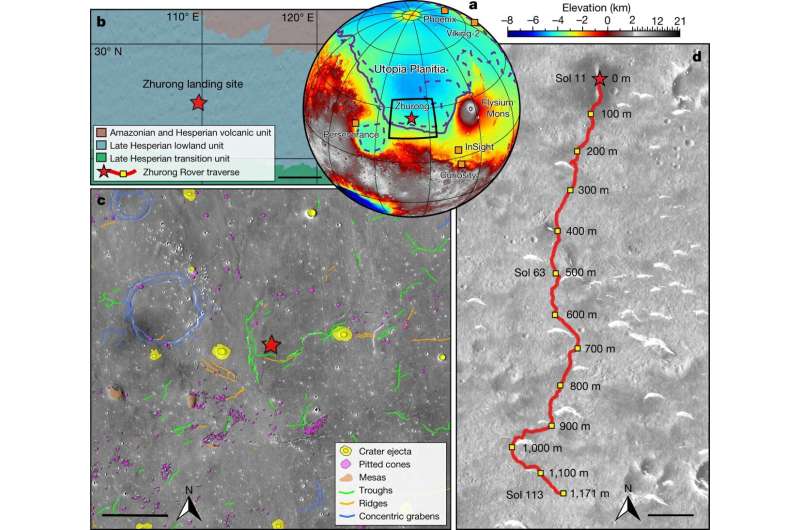
China's National Space Administration landed the Zhurong rover on the red planet in May of 2021. Since that time, it has been rolling across the Utopia Planitia basin—an impact crater—studying the terrain around it and the material that lies beneath. To date, the rover has traveled approximately 1,171 meters. The rover is equipped with ground-penetrating radar, which has been fired continuously at the ground as the rover moves, allowing the researchers to create an underground map for depths from 3 to 10 meters. The rover also has a device that can send low-frequency radio waves into the ground at depths up to 100 meters, though its resolution is much lower than the radar.
The researchers found that there are at least two layers of material beneath the basin, neither of which are believed to be water. One of the layers was approximately 10 to 30 meters down and the other from 30 to 80 meters down.
Neither the radar nor the radio waves are capable of discerning the difference between rock and ice or lava. Thus, the researchers have resorted to theories to explain the layers beneath the ground. They suggest it is likely that the deeper, older layer came about as smaller rocks settled onto bigger rocks during a flood approximately 3 billion years ago.
The formation they found would require the flood to have been a fast one with enough energy to carry large rocks. The researchers suggest the second layer could have come about in similar fashion—by a flood approximately 1.6 billion years ago. They note that prior research has suggested there was a lot of glacial activity during that time period. They also note that they did not find any evidence of volcanic activity that could have resulted in the creation of either layer.
More information: Chao Li et al, Layered subsurface in Utopia Basin of Mars revealed by Zhurong rover radar, Nature (2022). DOI: 10.1038/s41586-022-05147-5
Journal information: Nature
© 2022 Science X Network


