NASA looks at Louisiana delta system, eyes global forecasts

Erosion, sinking land and sea rise from climate change have killed the Louisiana woods where a 41-year-old Native American chief played as a child. Not far away in the Mississippi River delta system, middle-school students can stand on islands that emerged the year they were born.
NASA is using high-tech airborne systems along with boats and mud-slogging work on islands for a $15 million, five-year study of these adjacent areas of Louisiana. One is hitched to a river and growing; the other is disconnected and dying.
Scientists from NASA and a half-dozen universities from Boston to California aim to create computer models that can be used with satellite data to let countries around the world learn which parts of their dwindling deltas can be shored up and which are past hope.
"If you have to choose between saving an area and losing another instead of losing everything, you want to know where to put your resources to work to save the livelihood of all the people who live there," said lead scientist Marc Simard of NASA's Jet Propulsion Laboratory.
While oceans rise because of climate change, the world's river deltas—home to seafood nurseries and more than 300 million people—are sinking and shrinking.
To figure out where to shore up dying deltas, NASA is studying water flowing in and out of Louisiana's Atchafalaya and Terrebonne basins, sediment carried by it, and plants that can slow the flow, trap sediment and pull carbon from the air.
, underneath a King Air twin engine airplane, before one of many flights over the Atchafalaya River delta to measure surface water velocity, at New Orleans Lakefront Airport, in New Orleans on Wednesday, April 7, 2021. Credit: AP Photo/Gerald Herbert")
Louisiana holds 40% of the nation's wetlands, but they're disappearing fast—about 2,000 square miles (5,180 square kilometers) of the state have been lost since the 1930s. That's about 80% of the nation's wetland losses, according to the U.S. Geological Survey.
Using two kinds of radar and a spectrometer that measures more colors than the human eye can distinguish, high-altitude NASA airplanes have been collecting information such as water height, slope, sediment, and the types and density of plants. Some measurements are as precise as a couple of centimeters (less than an inch).
On boats and islands, scientists and students from across the country take samples and measure everything from currents to diameters of trees. Their findings will be used to calibrate the airborne instruments.
"I've been working here 15 years, and one of the toughest parts about working in a delta is you can only touch one little piece of it at any one time and understand one little piece of it at one time," said Robert Twilley, a professor of oceanography and coastal sciences at Louisiana State University. "Now we have the capability of working with NASA to understand the entire delta."

The Mississippi River drains 41% of the continental United States, collecting 150 million tons (130 million metric tons) of sediment per year. But, largely because of flood-prevention levees, most sediment shoots into the Gulf of Mexico rather than settling in wetlands.
"Deltas are the babies of the geological timescale. They are very young and fragile, in a delicate balance of sinking and growing," NASA states on the Delta-X project website.
In geological time, young means thousands of years. On that scale, Louisiana's Wax Lake Delta is taking its first breaths. It dates to 1942, when the Army Corps of Engineers dug an outlet from the lake to reduce flood threats to Morgan City, about 20 miles (32 kilometers) away. Sediment from the Atchafalaya River filled the lake, then began creating islands in the Gulf.
The new islands are thick with black willows and, in spring, thigh-high butterweed topped with small yellow flowers.
 GPS to take measurements on Mike Island, part of the Wax Lake Delta in the Atchafalaya Basin, in St. Mary Parish, La., Friday, April 2, 2021. NASA is using high-tech airborne systems along with boats and mud-slogging work on islands for a $15 million study of these two parts of Louisiana's river delta system. Credit: AP Photo/Gerald Herbert")
Older wetlands in areas surveyed by Delta-X aircraft are more diverse, their soil rich with humus from generations of plants. Along nearby Hog Bayou, blue buntings and scarlet tanagers dart through magnolia branches and skinks skitter up trees. In swamps, ospreys nest atop bald cypresses and alligators float in the water below.
In addition to working at LSU, Twilley has spent about nine years as executive director of Louisiana Sea Grant College Program, which uses the Wax Lake Delta as a classroom for middle- and high-school students.
"We take kids and make them stand on land that was formed the year they were born." Twilley said.
In contrast, the adjacent Terrebonne Basin is shrinking so rapidly that the government is paying to move the Isle de Jean Charles band of Biloxi-Chitimacha-Choctaw Indians from a vanishing island to higher ground.

That band isn't the only Native American group losing ground.
"The wooded areas we used to run through as children—they're dead," said Chief Shirell Parfait-Dardar of the Grand Caillou/Dulac Band of Biloxi-Chitimacha Indians, based less than 50 miles (80 kilometers) from the Wax Lake Delta.
"Ghost forests" are common in degrading deltas where salt water intrudes as land sinks and erodes, LSU's Twilley said.
Louisiana is considering two projects that would divert Atchafalaya River sediment to build land in the Terrebonne Basin, but a decision is more than a year away, according to the state Coastal Restoration and Preservation Authority.
Delta-X's study gets downright granular. A California Institute of Technology team that studies how sediment moves and is deposited on Earth and other planets will analyze the amounts of sediment in high- and low-tide water samples, breaking the particles down into about 100 sizes.
 GPS to take measurements on Mike Island, part of the Wax Lake Delta in the Atchafalaya Basin, in St. Mary Parish, La., Friday, April 2, 2021. NASA is using high-tech airborne systems along with boats and mud-slogging work on islands for a $15 million study of these two parts of Louisiana's river delta system. Credit: AP Photo/Gerald Herbert")
One way LSU researchers measure how much land has been formed by sediment involves sprinkling white feldspar dust on the ground.
They return to see how deeply it's buried by new sediment. They do that by injecting liquid nitrogen into hollow tubes to freeze the dirt and muck around them. When the tubes are pulled up, the frozen "popsicles" show a white ring. They measure from there to the top.
In the Terrebonne Basin, such sedimentation can't keep up with subsidence and sea level rise. "Thus the wetlands basically drown," Twilley said.
Planes and boats went out in March and April and will go out again in fall for a second set of measurements. And two international satellites are scheduled for launch next year, each carrying one of the two kinds of radar used over Louisiana.
To gauge how plants affect water movement, long-wavelengths of L-band radar can measure water level changes in open and vegetated channels, NASA's Simard said. And high-frequency Ka-band radar can measure surface height of open water, showing how it slopes—and where it's moving.
-
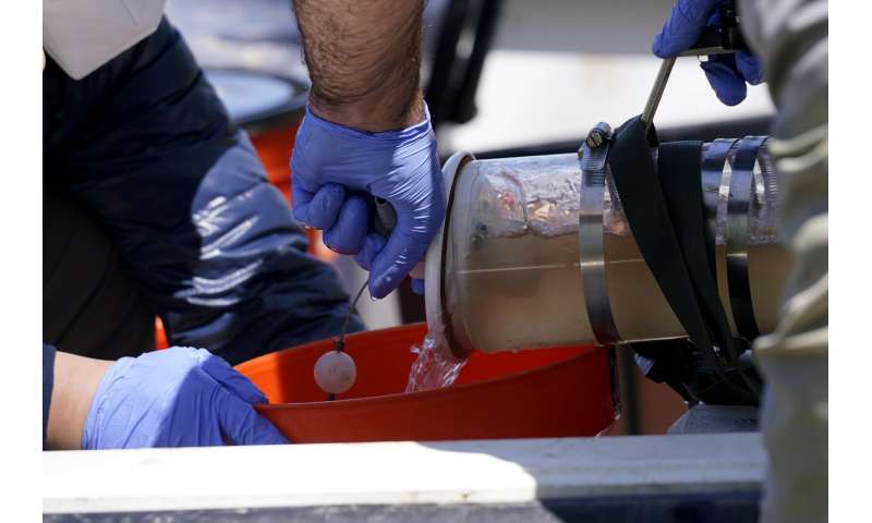
Mike Lamb, co-investigator, from the California Institute of Technology, and Gen Li, post doctoral scholar, left, capture water samples to measure sediment in the water, on Mike Island, part of the Wax Lake Delta in the Atchafalaya Basin, in St. Mary Parish, La., Friday, April 2, 2021. NASA is using high-tech airborne systems along with boats and mud-slogging work on islands for a $15 million, five-year study of these adjacent areas of Louisiana. One is hitched to a river and growing; the other is disconnected and dying. Credit: AP Photo/Gerald Herbert -
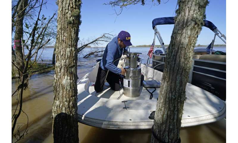
Andre Rabay, research scientist for the LSU Department of Oceanography and Coastal Science prepares a canister of liquid nitrogen that he will use to freeze samples of the ground on Mike Island, part of the Wax Lake Delta in the Atchafalaya Basin, in St. Mary Parish, La., Friday, April 2, 2021. NASA is using high-tech airborne systems along with boats and mud-slogging work on islands for a $15 million study of these two parts of Louisiana's river delta system. Credit: AP Photo/Gerald Herbert
"All of the tools they're bringing to bear is really impressive," said Indiana University sedimentary geologist Douglas Edmonds, who is not part of the project but has worked with many of the researchers.
"The project itself is putting a finger on a really essential question for a lot of deltas around the world—how this deltaic land is formed and what processes take it away," he said.
© 2021 The Associated Press. All rights reserved. This material may not be published, broadcast, rewritten or redistributed without permission.


