A simple way to predict tropical cyclones undergoing rapid intensification

"Yellow streaks in sunset sky, wind and daylong rain is nigh." This old weather proverb originates from fishermen who found colors and shapes in clouds at sunset could predict an incoming storm. Nowadays, state-of-the-art satellite observations for tropical cyclone cloud structures, as well as the evolution of surrounding weather systems, are utilized to assist weather forecasters to make decisions. Indeed, rapid intensity changes often occur in conjunction with rapid reorganization of the tropical cyclone's mesoscale cloud and precipitation structures.
Super Typhoon Rammasun (2014) is the strongest-recorded TC at landfall over the Chinese mainland since 1949. By using satellite observations and high-resolution ensemble simulation output, Dr. Yihong Duan and his team—a group of researchers from the Hainan Key Laboratory of South China Sea Meteorological Disaster Prevention and Mitigation, the State Key Laboratory of Severe Weather, China Meteorological Administration, and the Australian Bureau of Meteorology—have had their findings about the precursors of Rammasun's onset of rapid intensification (RI) published in Advances in Atmospheric Sciences.
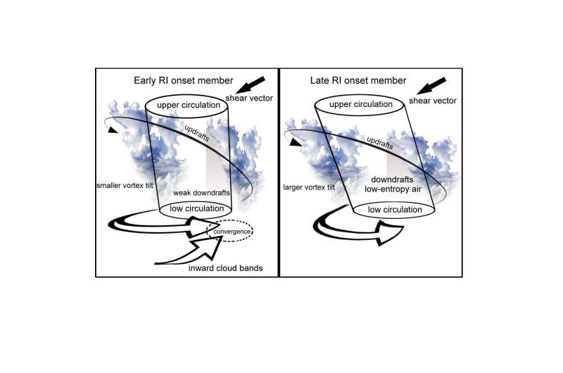
For the early RI onset member, strong ascent develops over the downshear flank at radii beyond the radius of maximum wind, merging inward-penetrating inner cloud bands that become deep convections while the vortex core becomes upright. Thus, the Synchronization Index, a simple measure of the amount of coherence in the vertical structure of the circulation, is proposed by Dr. Noel Davidson, one of the authors of the current study.
"The Synchronization Index presented here is a useful way of monitoring vortex structure, though it is only based upon our analysis of an ensemble of RI forecasts for one case study," says Dr. Duan. "We plan to extend the study by making further analyses and budget diagnoses from the members, to better understand the processes that influence RI."
More information: Xun Li et al, Analysis of an Ensemble of High-Resolution WRF Simulations for the Rapid Intensification of Super Typhoon Rammasun (2014), Advances in Atmospheric Sciences (2020). DOI: 10.1007/s00376-019-8274-z
Provided by Chinese Academy of Sciences


