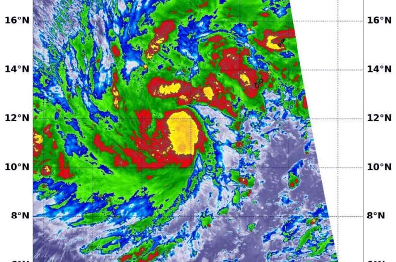
NASA-NOAA satellite finds tropical storm Kammuri strengthening

NASA-NOAA's Suomi NPP satellite passed over Tropical Storm Kammuri in the Northwestern Pacific Ocean and found several areas of very strong thunderstorms.
The Visible Infrared Imaging Radiometer Suite (VIIRS) instrument aboard Suomi NPP provided an infrared image of the storm on Nov. 27 at 0424 UTC (Nov. 26 at 11:24 p.m. EST). Infrared imagery reveals cloud top temperatures, and the higher the cloud top, the colder it is, and the stronger the storm.
The VIIRS instrument found several areas within where cloud top temperatures were as cold as minus 80 degrees Fahrenheit (minus 62.2 Celsius), indicating powerful storms. Kammuri continued to strengthen and consolidate. The most powerful thunderstorms were located around the center of circulation and in a fragmented band of thunderstorms north of the center. Storms with cloud tops that cold have been found to generate heavy rainfall.
At 4 a.m. EST (0900 UTC7 p.m. CHST, Guam local time) on Nov. 27, the National Weather Service in Tiyan, Guam noted the center of Tropical Storm Kammuri was located near latitude 11.7 degrees north and longitude 140.6 degrees east. Kammuri is centered about 130 miles north-northeast of Ulithi, 135 miles north of Fais, 230 miles northeast of Yap and about 310 miles west-southwest of Guam.
Guam, Rota, Tinian, and Saipan are no longer under a Tropical Storm Warning. However, a flash flood watch remains in effect for Guam and the Northern Marianas.
Kammuri is moving west at 16 mph. It is expected to make a turn toward the north-northwest with a decrease in forward speed over the next 24 hours. Maximum sustained winds remain at 65 mph. Tropical storm force winds extend outward from the center up to 240 miles to the northeast and up to 155 miles elsewhere.
Kammuri is forecast to intensify through Thursday possibly becoming a typhoon. It is also forecast to turn north and then head west after two days toward the Philippines.
Typhoons and hurricanes are the most powerful weather event on Earth. NASA's expertise in space and scientific exploration contributes to essential services provided to the American people by other federal agencies, such as hurricane weather forecasting.
More information: For updated forecasts, visit: www.weather.gov/gum/
Provided by NASA's Goddard Space Flight Center


