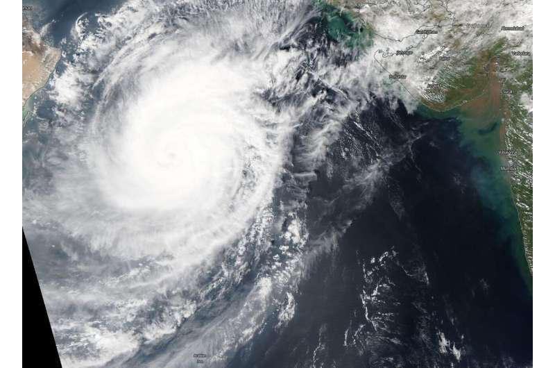
NASA find Tropical Cyclone Kyarr with a cloud-filled eye

NASA satellite imagery revealed that Tropical Cyclone Kyarr has maintained its eye, although that eye has become cloud-filled.
On Oct. 30, the Moderate Imaging Spectroradiometer or MODIS instrument that flies aboard NASA's Terra satellite provided a visible image on Kyarr as it tracks through the Arabian Sea. The MODIS image showed that the storm maintained an eye, but it had become filled with high clouds. The eye also appeared somewhat oblong, indicating that the storm is weakening. Large feeder bands, that is, bands of powerful thunderstorms that spiral into the low-level center, extended north and south of center.
The shape of the storm is a clue to forecasters that a storm is either strengthening or weakening. If a storm takes on a more rounded shape it is getting more organized and strengthening. Conversely, if it becomes less rounded or elongated, it is a sign the storm is weakening.
After the MODIS image was taken, a microwave satellite image revealed the defined oblong microwave eye feature, but the bulk of the deep convection (strong thunderstorms) were confined to the eastern semicircle.
At 5 a.m. EDT (0900 UTC) on Oct. 30, the center of Tropical Cyclone Kyarr was located near latitude 19.2 degrees north and longitude 61.8 degrees east. That puts the center about 184 nautical miles east-southeast of Masirah Island, Oman. Maximum sustained winds were near 90 knots (104 mph/167 kph).
The Joint Typhoon Warning Center or JTWC noted that Kyarr is moving toward the southwest. JTWC noted, "The system should weaken gradually as environmental conditions degrade with more rapid weakening expected after 24 hours due to increasing easterly upper-level convergent flow [where lines of equal atmospheric pressure are pressed together between a high-pressure area to the north and the tropical cyclone or low-pressure system] and potentially dry air entrainment [dry air moving into the storm and sapping the moisture that helps create the thunderstorms the make up the storm]."
Hurricanes are the most powerful weather event on Earth. NASA's expertise in space and scientific exploration contributes to essential services provided to the American people by other federal agencies, such as hurricane weather forecasting.
Provided by NASA's Goddard Space Flight Center


