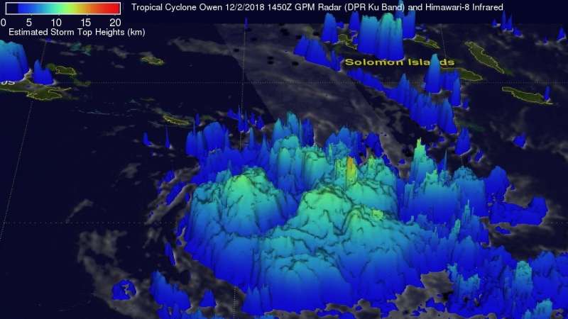
NASA catches newborn Tropical Cyclone Owen's rainfall, observed by GPM satellite

Tropical Cyclone Owen formed in the Southern Pacific Ocean's Coral Sea southwest of the Solomon Islands when the GPM core observatory satellite passed above and analyzed its rainfall.
On December 2, 2018 at 9:50 a.m. EST (1450 UTC) data collected by GPM's Microwave Imager (GMI) and GPM's Dual-Frequency Precipitation Radar (DPR) instruments aboard the Global Precipitation Measuring Mission or GPM core satellite showed that tropical cyclone Owen was producing heavy downpours. GPM's GMI indicated that heaviest rainfall was occurring near the low level center of circulation and in feeder bands that were wrapping around Owen's eastern side. GPM's GMI provided the best coverage of rainfall in the center of the tropical cyclone. GMI showed that storms in that area were dropping rain at a rate of over 53 mm (2.1 inches) per hour. GPM's radar (DPR Ku Band) probed storms on Owen's eastern side. DPR indicated that a few of these intense storms, far from Owen's center, were dropping rain at a rate of over 94 mm (3.7 inches) per hour.
A 3-D animation created with the data showed a simulated flyby above tropical cyclone Owen. GPM's radar (DPR Ku Band) probes into a feeder band on the eastern side of tropical cyclone Owen showed that a few powerful storms there were reaching heights above 15 km (9.3km). DPR's Ku Band radar enables accurate three dimensional measurements of precipitation within a 152 mile (245 km) wide swath. The heights of precipitation over a larger area were estimated by blending measurements from
GPM's radar (DPR Ku band) with heights based on the Himawari-8 satellite's infrared temperatures.
On Dec. 3 at 10 a.m. EST (1500 UTC) Tropical cyclone Owen was located near 15.7 degrees south latitude and 155.8 degrees east longitude. That's 579 miles east of Cairns, Australia. Owen is moving to the east-southeast and has maximum sustained winds 50 knots (57 mph/92.6 kph)
Owen is forecast to move southeast, later west. The storm will strengthen slightly before weakening as it turns west. Owen will dissipate after two days.
Provided by NASA's Goddard Space Flight Center


