NASA observes Tropical Storm Miriam's formation

Tropical cyclones continue to regularly develop in the Eastern Pacific Ocean. As Tropical Storm Miriam was developing, the GPM or Global Precipitation Measurement mission or GPM core satellite observed the rainfall happening within the storm.
Tropical Depression Fifteen-E (TD15E) formed in the eastern Pacific Ocean about 1,000 nautical miles (1852 km) southwest of the Baja California peninsula early on Sunday Aug. 26, 2018. TD15E became better organized with increased banding later in the day and was upgraded by the National Hurricane Center (NHC) to tropical storm Miriam.
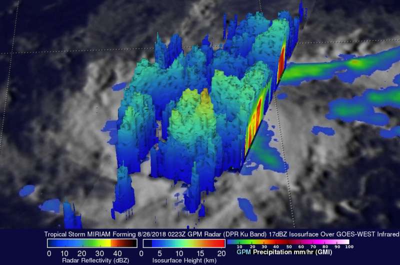
The GPM core observatory satellite saw the forming tropical storm earlier on Aug. 26 at 0223 UTC (Aug. 25 at 10:23 p.m. EDT). Heavy rainfall near the center of the forming tropical cyclone was examined with the GPM satellite's Microwave Imager (GMI) and Dual-Frequency Precipitation Radar (DPR) instruments. GPM's Radar (DPR Ku Band) revealed that extremely heavy rainfall was occurring within the organizing storm. GPM's radar measured rain falling at over 190 mm (7.5 inches) per hour in one powerful storm.
GPM's radar data (DPR Ku Band) revealed the 3-D structure of precipitation within storms in the forming tropical cyclone. The most powerful storm in this simulated 3-D view from the north-northeast was shown by GPM's radar to reach heights of about 15 km (9.3 miles). Energy, known as the latent heat of condensation, is released when precipitation occurs within these tall storms. This energy provides some of the fuel needed to form and sustain tropical cyclones. GPM is a joint mission between NASA and the Japan Aerospace Exploration Agency, JAXA.
At 11 a.m. EDT (1500 UTC) on Aug. 27 the center of Tropical Storm Miriam was located near latitude 13.9 degrees north and longitude 130.5 degrees west. That's about 1,485 miles (2,385 km) west-southwest of the southern tip of Baja California, Mexico.
Miriam is moving toward the west near 14 mph (22 kph), and this general motion is expected to continue for the next couple of days. A turn toward the west-northwest is expected on Thursday. On the forecast track, Miriam will approach the central Pacific basin late Wednesday or Wednesday night.
Maximum sustained winds have increased to near 65 mph (100 kph) with higher gusts. Additional strengthening is forecast during the next 2 to 3 days, and Miriam is expected to become a hurricane tonight or early Tuesday, Aug. 28.
The National Hurricane Center (NHC) predicts that Miriam will intensify as it moves toward the west along the southern periphery of the strong ridge to its north. Miriam is expected to become a hurricane tomorrow. The hurricane is expected to make a turn to the north in a few days as it moves into the central Pacific Ocean. Miriam is then forecast to weaken back to tropical storm intensity on September 1, 2018.
Provided by NASA's Goddard Space Flight Center


