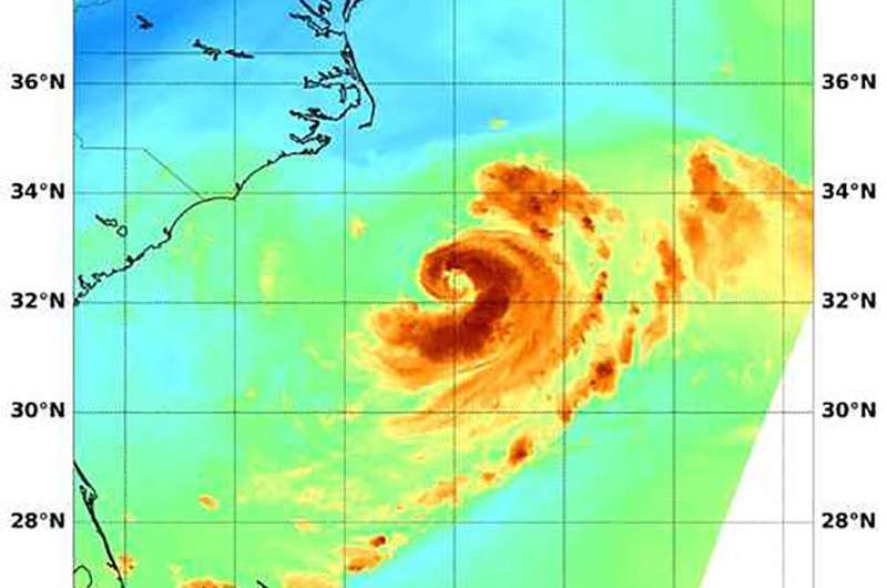
Tropical Storm Chris gives NASA satellite a signature 'C'

When NASA's Aqua satellite passed over the northwestern Atlantic Ocean, an instrument aboard looked at Tropical Storm Chris' water vapor and cloud temperatures. Appropriately, the image showed a backwards "C" or comma shaped storm. The water vapor imagery indicated Tropical Storm Chris has the potential to generate heavy rainfall.
NASA's Aqua satellite passed over Chris on July 10 at 3:15 a.m. EDT (0715 UTC) and analyzed the water vapor content within the storm. Water vapor imagery is used to analyze the movement and presence of water vapor moisture in the middle and upper levels of the atmosphere. Those levels range from about 650 millibars to the top of the troposphere.
The MODIS or Moderate Resolution Imaging Spectroradiometer instrument aboard NASA's Aqua satellite showed cloud top temperatures as cold or colder than minus 70 degrees Fahrenheit (minus 56.6 degrees Celsius). Cloud tops with temperatures that cold have the potential to generate very heavy rainfall.
There are no coastal watches or warnings in effect, however, the National Hurricane Center (NHC) cautioned that interests along the coast of North Carolina and in Atlantic Canada should monitor the progress of this system.
At 5 a.m. EDT (0900 UTC) on July 10 the center of Tropical Storm Chris was located near latitude 32.6 degrees north and longitude 73.9 degrees west. That's about 200 miles (325 km) south-southeast of Cape Hatteras, North Carolina. Maximum sustained winds are near 70 mph (110 kph) with higher gusts. Chris was moving toward the northeast near 2 mph (4 kph), and a faster northeastward motion is expected today and tonight. Chris is forecast to further accelerate toward the northeast on Wednesday and Thursday.
The NHC said "Chris is forecast to strengthen into a hurricane later today and some additional strengthening is expected through Wednesday night. Chris is forecast to become a strong post-tropical cyclone by Thursday night or early Friday.
Although Chris is not near land, swells generated by Chris are expected to increase and affect portions of the coasts of North Carolina and the Mid-Atlantic states during the next few days. These swells could cause life-threatening surf and rip current conditions.
Provided by NASA's Goddard Space Flight Center


