NASA sees powerful Tropical Cyclone Enawo threatening Madagascar

Tropical Cyclone Enawo has continued to intensify while moving toward Madagascar. NASA's Aqua satellite showed the development of an eye, while the Global Precipitation Measurement mission or GPM found heavy rainfall in the storm.
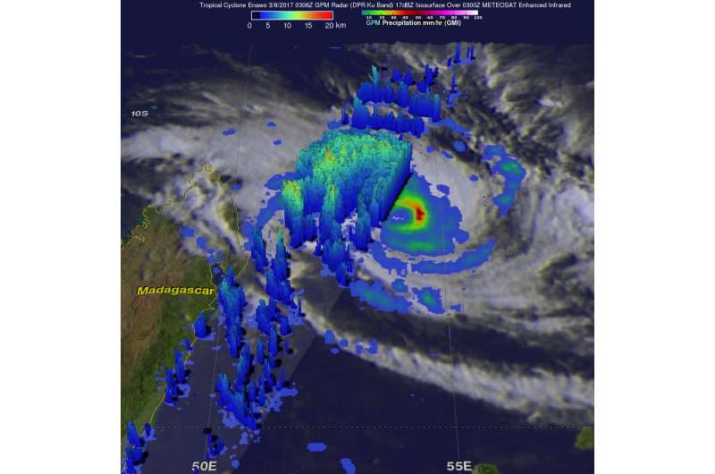
Enawo had winds of about 103.6 mph (90 knots/166.7 kph) when the GPM core observatory satellite flew over on March 6, 2017 at 0306 UTC (0606 a.m. local time/ Mar. 5 at 10:06 p.m. EDT). These powerful winds make Enawo the equivalent of a category two hurricane on the Saffir-Simpson Hurricane wind scale. GPM revealed that the tropical cyclone had heavy rainfall in distinct feeder bands on the western side and in the northeastern side of the eyewall. Precipitation was measured by GPM's DPR falling at a rate of over 220 mm (8.7 inches) per hour in intense downpours.
GPM's radar (DPR Ku Band) was used to perform a 3-D inspection of storms in the feeder bands on the western side of the tropical cyclone. This evaluation showed that many of these storms were reaching altitudes above 16 km (9.9 miles). GPM is a joint mission between NASA and the Japanese space agency JAXA.
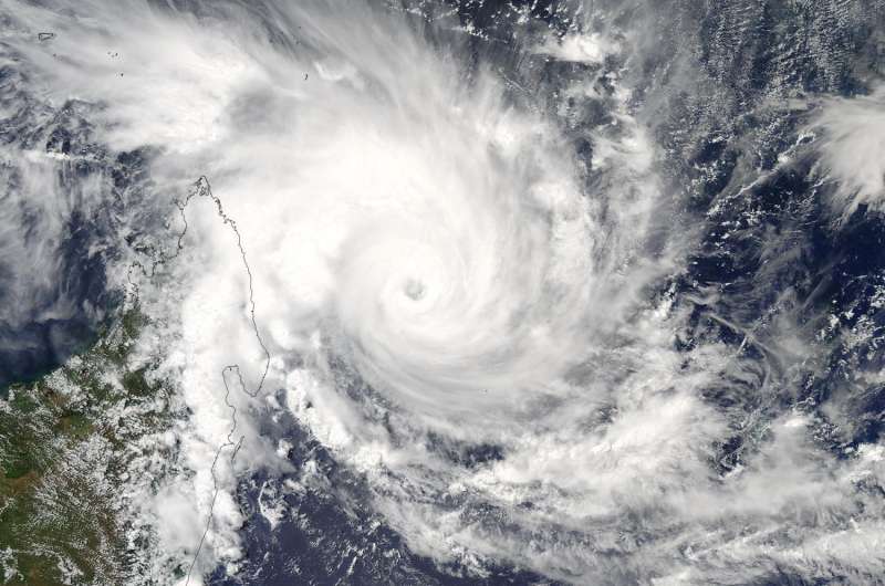
About seven hours later at 10:10 UTC (5:10 a.m. EST) the Moderate Resolution Imaging Spectroradiometer or MODIS instrument aboard NASA's Aqua satellite captured a visible image of Tropical Cyclone Enawo. The MODIS image showed powerful thunderstorms wrapped around the eye of the storm, while a thick band of thunderstorms fed into the low-level center from the north and west. Part of that band of thunderstorms were over northeastern Madagascar.

At 0900 UTC (4 a.m. EST) Enawo's maximum sustained winds were near 103.6 mph (90 knots/166.7 kph) and strengthening. Enawo was located near 14.0 degrees south latitude and 53.8 degrees east longitude. That's about 399 nautical miles north-northwest of La Reunion Island.
Intensifying tropical cyclone Enawo continues to be steered toward northeastern Madagascar. The tropical cyclone's winds are expected to reach 115 mph (100 knots/185 kph) before hitting Madagascar's northeastern coast early (UTC) on March 7, 2017. Enawo is then predicted to gradually weaken to tropical storm force while moving southward over Madagascar passing just east of Antananarivo on March 9.
The Madagascar Meteorological Service has placed the following regions under alert:
A Red Alert or Alerte Rouge is in effect for: Sur Vohimarina, Andapa, Sambava, Antalaha, Soanierana-Ivongo, Vavatenina, Fenoarivo-Atsinanana, Mananara-Avaratra, Maroantsetra, Sainte Marie.
A Yellow Alert or Alerte Jaune is in effect for: Sur Ambanja, Nosy-Be, Ambilobe, Antsiranana, Mampikony, Bealanana, Antsohihy, Befandriana-Avaratra, Analalava, Mandritsara, Port-Berger, Anosibe-Anala, Andilamena, Moramanga, Ambatondrazaka, Amparafaravola, Antanambao-Manampotsy, Marolambo, Mahanoro, Vatomandry, Vohibinany, Toamasina.
A Green Alert or Alerte Verte is in effect for: Sur Kandreho, Tsaratanana, Mitsinjo, Marovoay, Ambato-Boina, Maevatanana, Mahajanga, Manandriana, Vohipeno, Ikongo, Manakara-Atsimo, Mananjary, Nosy-Varika, Ifanadiana, Fandriana, Ambositra, Ambatofinandrahana, Fenoarivo-Afovoany, Antananarivo-Atsimondrano, Faratsiho, Andramasina, Antanifotsy, Soavinandriana, Miarinarivo, Tsiroanomandidy, Ambatolampy, Betafo, Antsirabe, Anjozorobe, Manjakandriana, Arivonimamo, Ankazobe, Ambohidratrimo, Antananarivo.
For updated forecasts from Madagascar's Meteorological Services, visit: http://www.meteomadagascar.mg/.
Provided by NASA's Goddard Space Flight Center


