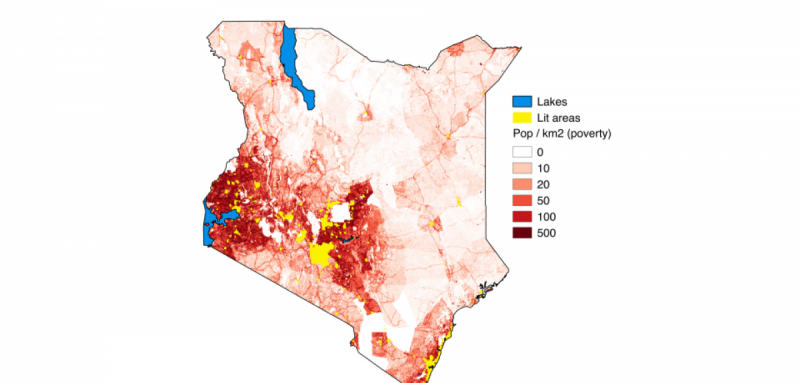
Satellite images show poor populations around the world in darkness at night

Economists from the University of Oxford have come up with a novel approach for measuring global poverty – counting the number of people who live in darkness at night.
Researchers analysed two separate datasets from satellites: the first showed images of all the areas of the world that light up at night, and the second estimated population using images of roads, buildings and other signs of human habitation. Both satellites covered every square kilometre around the world, amounting to 100 million data points every year. By combining the two datasets into one, the researchers identified places in the world where populations have no night-time lights. They find this accurately identifies people in poverty after comparing it with over 600,000 household surveys, and is faster, cheaper and has better coverage than the surveys typically used to measure poverty.
The study shows that oil booms increase inequality and do not benefit the rural poor. The benefits of oil discoveries and high oil prices appear to be limited to towns and cities, which become more illuminated (which the researchers use as a proxy for greater economic activity). However, there is no evidence of a wealth trickle-down effect, as the areas where the rural poor live remained unlit through a decade of high oil prices (2003-2013).
Overall, 30% of people outside the OECD (Organisation for Economic Co-operation and Development) lived in darkness at night, as did over half the population of Africa, says the study. The paper lists nearly 40 countries where inequalities between rich and poor are greatest. For example, in 2013, it finds that in the Democratic Republic of Congo 97% of people in unlit areas were poor, compared with 33% in lit areas; in Bolivia, 82% of people left in the dark were poor, compared to just 15% of those with lighting.
In the ten years after an oil discovery, the percentage of rural poor living in unlit areas only fell by 1% on average compared with countries where oil is not found. In contrast, oil discoveries in that period increased the illumination in cities and towns by 14% and 22%, respectively, as compared with a control group.
The study looks at why poor rural areas light up and find it is not linked with oil booms or discoveries. The deciding factors appear to be population size, whether they are close to other lit areas, or proximity to the capital city. The research also finds that countries receiving oil revenues do not appear to systematically invest the money in larger electricity networks that would benefit those living outside towns or cities.
Researcher Dr Samuel Wills, from the Department of Economics at the University of Oxford, comments: 'Switching on the lights has a large payoff because it lets people work and study after the sun goes down. People therefore tend to turn the lights on very soon after they leave extreme poverty. Our results suggest that oil booms have not brought benefits to the poorest in oil-rich countries. Indeed, the good fortune of discovering oil benefits only part of the population: those living in towns and cities. If anything, they create greater inequality as oil-rich countries appear to be less efficient at converting growth to reducing poverty than those countries without oil.'
The study finds that a decade of high oil prices, starting in 2003, saw night-time illumination in oil-rich countries grow by nearly a third relative to those without oil on average, with similar effects for GDP per capita. It says a major oil discovery with a net present value worth 100% of GDP increased levels of lighting by nearly one fifth, on average, and GDP by 8% between 2003 and 2013 (after taking all other factors into account).
The researchers used datasets from satellites used by the United States Department of Defence that show night-time lights around the world since 1992, with each grid at a resolution of around one square kilometre. This was combined with satellite data from LandScan showing roads, buildings, dwellings and other key indicators of population distribution, widely accepted as the finest resolution global population distribution data available.
The researchers also analysed oil prices and oil discoveries to see how they affected changes in levels of illumination. They used Brent crude prices from 1990-2013 (which rose from $20 per barrel in 2002 to over $110 per barrel in 2013) and data on giant oil and gas discoveries from the American Association of Petroleum Geologists.
More information: Left in the Dark? Oil and Rural Poverty: www.oxcarre.ox.ac.uk/images/st … oxcarrerp2015164.pdf%20
Provided by University of Oxford


