Ocean engineering students study impact of rising sea levels
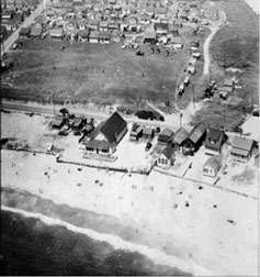
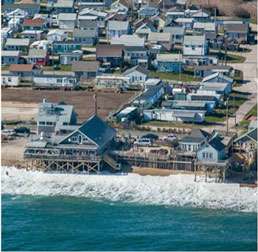
It's no secret that rising sea levels and storms are threatening Rhode Island's coastal communities. Now University of Rhode Island students are studying one community that could be hit especially hard: Matunuck.
The yearlong analysis by eight senior ocean engineering students is so thorough that flooding projections were made for specific structures —709 to be exact.
Those home and business owners will be able to find out what could happen to their buildings during a powerful storm with rising sea levels up to 5 feet.
The students teamed up with Malcolm Spaulding, professor emeritus of ocean engineering at URI who has created a computer-based program called STORMTOOLS that gives property owners and cities and towns a more complete understanding of flood risks.
Using the program, property owners simply enter their address and find out what lies ahead for their buildings. They learn how deep the floodwaters will be during a storm, and the impact of rising seas on their property. The tool uses graphics and satellite images to create maps that show water levels for 25-year, 50-year and 100-year storms and sea-level rise of 1, 2, 3 and 5 feet.
"It's proving to have some legs,'' Spaulding says, of the program. "A lot of people are using it. People in the coastal areas are increasingly concerned about these kinds of issues.''
Climate change will bring profound changes to Rhode Island's coastal communities in the coming decades. Scientists project sea levels to rise 3 to 5 feet in the state by 2100, and recent government projections are as high as 7 feet, Spaulding says.
The URI students selected Matunuck because it has one of the highest erosion rates on the southern coast of Rhode Island. The 709 houses and businesses they identified are all in an area prone to flooding. The results were alarming. With a 100-year storm and sea-level rise of 5 feet, 431 houses would be damaged.
And that's important information for homeowners making plans for the future, says Spaulding. Property owners, for example, might consider elevating their houses or businesses, or taking other steps now.
The study could also help communities make decisions about whether to build in an area that could flood, or install shore protection systems. Planners also might consider new evacuation routes based on the students' flooding projections.
Policymakers trying to figure out which communities in the state are at risk also benefit. The analysis helps the Rhode Island Coastal Resources Management Council and the group's Beach Special Area Management Plan. "STORMTOOLS will be an integral part of the CRMC's approach to managing the Rhode Island shoreline," says Grover Fugate, director of CRMC.
The online tool puts Rhode Island ahead of the pack nationally, says Teresa Crean, coastal community planner for URI's Coastal Resources Center and Rhode Island Sea Grant. She's held workshops in North Kingstown, Narragansett, Charlestown, Westerly, and Block Island about STORMTOOLS, and all were enthusiastic about its potential.
"Rhode Island's coastal communities have access to a high- resolution tool that other states in the country don't have at their disposal,'' Crean says. "This tool allows cities and town to move forward with understanding risk and helps them prepare for coastal storms and projected sea-level rise.''
That was clear to students, who benefited by working on a project with relevance to the real world.
URI students Tyler Blanpied, Alicia Kauffman, Conor O'Neil, Nick Proulx, Matt Rajacich, Hailey Simpson, Chris Small and Jeff White will continue their work next semester.
Proulx, of Swansea, Mass., says the project has inspired him to look for work as a coastal engineer after he graduates. He also hopes the project sparks state and local leaders to move swiftly to protect coastal areas.
"We really want to raise awareness about sea-level rise and erosion rates,'' says Proulx. "Matunuck is a highly populated area, and the majority of houses are low-lying. Some people are unwilling to evacuate in an emergency, but our project shows the danger from these storms. I like to think what we're doing is cutting-edge and leads to a larger movement in the state.''
More information: For more information visit STORMTOOLS: www.beachsamp.org/2015/06/17/n … adaptation-planning/
Provided by University of Rhode Island


