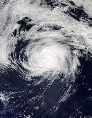
NASA catches a weaker Edouard, headed toward Azores

NASA's Aqua satellite passed over the Atlantic Ocean and captured a picture of Tropical Storm Edouard as it continues to weaken. The National Hurricane Center expects Edouard to affect the western Azores over the next two days.
NASA's Aqua satellite flew over Tropical Storm Edouard on Sept. 18 at 1:45 p.m. EDT and the Moderate Resolution Imaging Spectroradiometer (MODIS) instrument took a visible picture that showed the eye had disappeared and the bulk of clouds pushed east of center.
At 5 a.m. EDT on Sept. 19, Edouard's maximum sustained winds had decreased to near 60 mph (95 kph). The storm's center was located near latitude 39.8 north and longitude 38.5 west. That's about 530 miles (855 km) west-northwest of Faval Island in the Western Azores.
Portugal's Azores Islands include nine volcanic islands in the North Atlantic Ocean. They are about 850 miles (1,360 km) west of continental Portugal.
Edouard is expected to become a post-tropical cyclone later on Sept. 19. Then it is forecast to head east and affect the western Azores Islands over the weekend of Sept. 20 and 21 before turning south and weakening to a depression.
Provided by NASA's Goddard Space Flight Center


